Capers Island, South Carolina
 Capers Island Capers Island (South Carolina) | |
| Geography | |
|---|---|
| Location | Atlantic Ocean |
| Coordinates | 32°51′07″N 79°41′49″W / 32.852°N 79.697°W |
| Area | 1.66 sq mi (4.3 km2) |
| Length | 3.11 mi (5.01 km) |
| Width | .53 mi (0.85 km) |
| Administration | |
|
United States | |
| State |
|
| County | Charleston County |
Capers Island is a state-owned barrier island on the Atlantic Ocean in Charleston County, South Carolina about 15 miles north of the city of Charleston. It is separated from the mainland by salt marshes and the Intracoastal Waterway. To the southwest it is separated from the barrier island Dewees Island by Capers Inlet. To the northwest, it is separated from the barrier island Bulls Island by Price Inlet.[1]
The island is named for Bishop William Theodotus Capers, a native of South Carolina.
Visiting
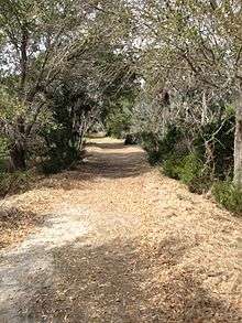
Capers Island is undeveloped and maintained by the State of South Carolina. There is a small dock on Capers Inlet that has a boardwalk across the marsh to an unpaved nature trail which leads to the beach approximately 1 mile to the southeast. Primitive camping is permitted however a free permit must be acquired from the State Department of Natural Resources and is limited to 50 campers per night.
Natural Habitat
Capers Island is a barrier island with a number of discrete habitats including:
- Maritime uplands
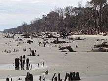
- Sandy beach
- Salt marsh
- Brackish ponds
Flora
Plant species on the island include:
Fauna
Numerous animal species inhabit the island and surrounding waters and marshes on a seasonal or permanent basis.
Mammals
Birds
Reptiles
Fish
Crustaceans
Mollusks
References
- ↑ "Capers Island Heritage Preserve". South Carolina Department of Natural Resources. Archived from the original on 28 November 2010. Retrieved 27 August 2014.