Carlingwark Loch
| Carlingwark Loch | |
|---|---|
|
Carlingwark Loch - geograph.org.uk - 1180333 | |
| Coordinates | 54°55′48″N 3°56′1″W / 54.93000°N 3.93361°WCoordinates: 54°55′48″N 3°56′1″W / 54.93000°N 3.93361°W |
| Type | freshwater loch |
| Primary inflows | Gelston burn[1] |
| Primary outflows | Carlingwark Lane[2] |
| Catchment area | 13.05 km2 (5.04 sq mi) |
| Basin countries | Scotland |
| Max. length | .075 mi (0.121 km)[2] |
| Max. width | 0.33 mi (0.53 km)[2] |
| Average depth | 7 ft (2.1 m)[2] |
| Max. depth | 17 ft (5.2 m)[2] |
| Water volume | 3,100,000 cu ft (88,000 m3)[2] |
| Surface elevation | 143 ft (44 m)[2] |
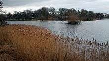
Carlingwark Loch is a small freshwater loch in Dumfries and Galloway, Scotland lying just south of Castle Douglas and is roughly rectangular in shape, trending nearly north and south. The name of the loch comes from the Scots Gaelic word Caer meaning fort and wark the old Scots language word for work.[3] There are four artificial islets in the loch showing evidence of fortification and settlement, Ash Island is thought to be a crannog. Several archaeological finds have been retrieved from the loch including a bronze cauldron, sword and pan and two dugout canoes.[4]
There is a 5.25 km (3.26 mi) footpath around the loch and it is popular for bird watching and fishing. As of 5 March 2012 the loch and the land around it has been designated as a Scottish Site of Special Scientific Interest on account of its varied birdlife and grassland.[5]
In 1903 the loch was surveyed[2] by E.R. Watson and later charted[6] as part of The Bathymetrical Survey of Fresh-Water Lochs of Scotland 1897–1909.[7]
In 2009 an aerating fountain was installed at a cost of £10,000 to try to prevent the build-up of blue-green algae. The funding was provided by South West Scotland Environmental Action Trust.[8] The installation of the fountain was part of a wider development of Carlingwark Outdoor Activity Centre by Dumfries and Galloway Council.[9]
References
- ↑ David M. Harper (30 September 1999). The Ecological Bases for Lake and Reservoir Management. Springer. pp. 295–. ISBN 978-0-7923-5785-8. Retrieved 24 July 2013.
- 1 2 3 4 5 6 7 8 "Bathymetrical Survey of the Fresh-Water Lochs of Scotland, 1897-1909, Lochs of the Dee (Kirkcudbright) Basin". National Library of Scotland. 23 July 2011. Retrieved 2013-07-24.
- ↑ "Doomsday reloaded: Carlingwark Loch, D-block GB-276000-561000". BBC. BBC. 1986. Retrieved 24 July 2013.
- ↑ "Site Record for Carlingwark Loch Ash Island; Fir Island". Canmore. RCAHMS. Retrieved 24 July 2013.
- ↑ "Site Details for Threave and Carlingwark Loch". Scottish Natural Heritage. Scottish Natural Heritage. 2013-07-11. Retrieved 2013-07-24.
- ↑ "Loch Dee; Loch Harrow; Loch Dungeon; Loch Grennoch; Lochinvar; Loch Skerrow, Lochenbreck Loch; Loch Whinyeon; Woodhall Loch; Carlingwark Loch (Vol. 5, Plate 44) - Bathymetrical Survey, 1897–1909 - National Library of Scotland". maps.nls.uk. Retrieved 2013-07-24.
- ↑ Murray, John; Pullar, Laurence (1910). Bathymetrical Survey of Fresh-Water Lochs of Scotland during the years 1897 to 1909: report on scientific results. Edinburgh. Retrieved 24 July 2013.
- ↑ "CARLINGWARK OUTDOOR ACTIVITY CENTRE - PROGRESS REPORT" (PDF). Dumfries and Galloway Council. 2009-04-15. Archived from the original (PDF) on 2014-07-14. Retrieved 2014-07-11.
- ↑ Lesley Walker (2009-08-25). "Scottish Loch sparkles this summer thanks to Otterbine Fountain". PitchCare. PitchCare. Retrieved 2014-07-11.