Ballowall Barrow
Coordinates: 50°07′20″N 5°42′05″W / 50.122306°N 5.701361°W
 Ballowall Barrow | |
 Shown within Cornwall | |
| Location |
St Just, Cornwall grid reference SW354313 |
|---|---|
| Coordinates | 50°07′20″N 5°42′05″W / 50.122306°N 5.701361°W |
| Type | Chambered tomb |
| Site notes | |
| Ownership | English Heritage |
| Public access | Yes |
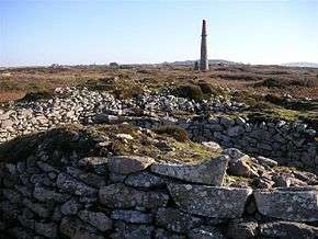
Ballowall Barrow (Cornish: Krug Karrekloos)[1] is a prehistoric funerary cairn (chambered tomb) which Ashbee (1982) and Hencken (1902–81) [2] state contains several phases of use from the Neolithic to the Bronze Age. It is situated on the cliff top at Ballowall Common, near St Just in Cornwall, England, UK. It is also known as Carn Gluze Barrow.[3]
It was first excavated in 1878 by William Copeland Borlase,[4] when it was discovered under mining debris. A report by Sharpe (1999)[3] states that there are several discrepancies in the accounts of the excavation work, some of the finds were lost and interpretation of the site is difficult. Reconstruction work which was done after the excavation to make the inside more accessible has further complicated the site. The site today is a confused mix of original and reconstructions introduced by Borlase.[5] The finds from excavations are in stored in museums at Truro, Cambridge and the British Museum [6]
The barrow is 72 feet (22 m) in diameter. The Cornwall and Scilly Historic Environment Record describes it as a central domed structure, containing cists and with a pit beneath, surrounded by an outer cairn also containing cists. An entrance grave is located in the external side of the outer cairn.
The construction of the site is unique in consisting of a combination of Neolithic and Bronze age funerary rituals.[7] A similar site was recorded by Borlase but its location has been lost.[7]
The site is a protected Scheduled monument (ref. number 15410). It was included in the Schedule on 10/8/1923 and the scheduling was updated on 22/2/1996.[8] The site is in the guardianship of English Heritage, and is managed by the National Trust.[9]
References
- ↑ List of place-names agreed by the MAGA Signage Panel Archived May 15, 2013, at the Wayback Machine. - Place-names in the Standard Written Form (SWF) Archived May 15, 2013, at the Wayback Machine.. Cornish Language Partnership.
- ↑ Cornish Archaeology; no 1, (1962) quoted in
- 1 2 Ballowall Bronze Age cairn
- ↑ "Ballowall Barrow". English Heritage. Retrieved 2008-06-14.
- ↑ Marsden, Barry M. (1974) The Early Barrow-diggers. Aylesbury: Shire (an expanded edition was issued in 1999 by Tempus, Stroud): Borlase was accustomed to excavate and then fail to make any proper record of the site.
- ↑ Pastscape
- 1 2 "Access to Monuments - Ballowall Barrow". . Cornwall County Council. 2007-09-14. Retrieved 2008-06-14. External link in
|work=(help) - ↑ HER Number: 29786, www.heritagegateway.org.uk
- ↑ Ballowall Barrow, English Heritage
External links
| Wikimedia Commons has media related to Ballowall Barrow. |