Carndochan Castle
| Carndochan Castle | |
|---|---|
| Llanuwchllyn, Gwynedd, Wales | |
 | |
 Carndochan Castle | |
| Coordinates | 52°51′40″N 3°42′50″W / 52.86105°N 3.71391°W |
| Type | Castle |
| Site information | |
| Condition | Ruins |
| Site history | |
| Built by | Llywelyn ap Iorwerth? |
Carndochan Castle (Welsh: Castell Carndochan) is a ruined stone castle near Llanuwchllyn, Gwynedd, north Wales. It was probably built in the early thirteenth century and is a Scheduled Ancient Monument.
History
The castle stands on a ridge overlooking the Lliw Valley; its early history is unrecorded, but it is thought to have been built by Prince Llywelyn ap Iorwerth between 1215 and 1230. Little is known of the site's history although King Edward I of England visited in 1283–84.[1]
Description
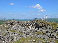
Built in typical Welsh style, it consisted of a D-shaped tower on its western end with smaller round or semi-round towers surrounding a small ward and square central tower.[2] The apsidal tower survives up to a height of 8 feet (2.4 m) and used a different source of lime for its coursed mortar that may indicate that it was built at a different time than the rest of the structure. Two of the other towers are dry stone-built and resemble to those at Cam Fadryn and Pen y Castell. A preliminary 2015 excavation in the southern part of the castle revealed the entrance, a small half-round tower and a length of curtain wall. The excavation recovered two pieces of charcoal that radiocarbon dating yielded dates of 1170–1258 for one and 1220–1271 for the other.[1]
It is not known when or why Carndochan was abandoned, although unsubstantiated excavations by nineteenth-century archaeologists apparently discovered substantial amounts of ash under the ruins, suggesting the castle was either sacked or demolished (often termed slighting).[3] Today, the site is protected as a scheduled monument.[1]
References
- 1 2 3 "Castell Carndochan, Dolhendre". Regional Historic Environment Record. Gwynedd Archaeological Trust. Retrieved 1 May 2016.
- ↑ A.H.A. Hogg, 'Castell Carndochan', Journal of the Merioneth Historical and Record Society Vol. 2, pp. 179–80 (1953-6).
- ↑ W. Hughes, 'Llanuwchllyn', Archaeologia Cambrensis Vol. 40, p. 189–90 (1885).
External links
- The Gatehouse Gazetteer with a comprehensive bibliography
 Media related to Carndochan Castle at Wikimedia Commons
Coordinates: 52°51′41.23″N 3°42′48.51″W / 52.8614528°N 3.7134750°W