Casterley Camp
 Casterley Camp | |
 Shown within Wiltshire | |
| Location | Wiltshire |
|---|---|
| Coordinates | 51°16′50″N 1°50′11″W / 51.2805°N 1.8365°W |
| History | |
| Periods | Iron Age |
| Site notes | |
| Public access | yes |
Casterley Camp is the site of an Iron Age univallate hillfort located in Wiltshire. The site comprises a large Iron Age/Romano-British enclosure, possibly non-defensive in function, and incomplete. The site was partially excavated in the 19th century.
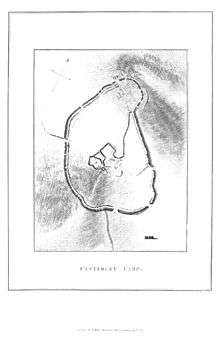
Three apparently related enclosures are identified situated within the site of Casterley Camp. Stock control and religious functions have been attributed to the enclosures. The excavations uncoverred Samian, New Forest and Coarse ware, coins, bronze earpicks, pins and tweezers, a stamp and knives, nails etc. There is also an Iron Age/Romano-British trackway on the west side of Casterley Camp, with traces of an earth banks on both sides. The site is a scheduled monument no.10037[1]
Location
The site is located at grid reference SU115535, to the southwest of the small village of Upavon, in the county of Wiltshire. The site lies at a level of between 155m and 175m AOD. There are public footpaths and bridleways to the north and west of the site. The Salisbury Plain firing ranges lie immediately to the west.
The smaller Iron Age hill fort of Chisenbury Camp lies close by to the east.
References
- ↑ "Extract from English Heritage's Record of Scheduled Monuments: Casterley Camp and associated monuments" (PDF). Retrieved 10 October 2010.
See also
- List of places in Wiltshire
- List of hill forts in England
- List of hill forts in Scotland
- List of hill forts in Wales