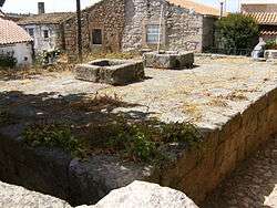
Castle of Castelo Bom
| Castle of Castelo Bom | |
|---|---|
| Castelo de Castelo Bom | |
.jpg) |
The Castle of Castelo Bom (Portuguese: Castelo de Castle Bom) is a medieval castle located in the civil parish of Castelo Bom, municipality of Almeida, Portuguese district of Guarda.
It is classified as a National Monument.
History

Early History
According to archaeological evidence, the early human occupation of its site dates dates back to the Bronze Age, where they had constructed a primitive fortress.
Medieval Era
During the Christian Reconquest Iberian peninsula, the region was first conquered by the Kingdom of León.
The fortress was later recorded in the Book of Fortresses c. 1509 during the reign of King Manuel (1495-1521). According to the book, the castle walls had two quadrangular towers, dominated by Donjon, with one barbican, also with two towers in the south to the north. The wall of the village was a double, with a tower to the northwest. The sovereign has renewed the Foral Charter in 1510, encouraging the restoration of the castle and around the village.
17th century to modern era
In the context of the War of Restoration, it was Captain-General of the village Vila Nova de Cerveira and Visconde de Lima Bridge Marquis. The castle had a bastion tower (where was the chain) and was defended by two artillery pieces and an important frontier defense post, having been used as a refuge by the governors of the border. It is believed to date from this period the Well d'El Rei and the Pit ladder.
Referenced in "Parish Memories of 1758", in the context of the Seven Years' War, when the invasion of Portugal in 1762, was surrounded and conquered. Later, at the time of the Peninsular War, invaded by Napoleonic troops, the castle was destroyed.
In the nineteenth century, before the extinction of Castle County Good (1834), inicou a period of decline, which led to the degradation of the remnants of the village defenses.
In the mid-twentieth century, the castle was classified as a National Monument, by Decree published on 2 January 1946.[1] By this time, the keep was still standing when it was demolished by an individual who intended to build a shelter there for your ass. Between 1987 and 1988, with the remnants of the partially buried castle, a study was undertaken to recover the castle by the Directorate General of National Buildings and Monuments (DGEMN).
Currently can be seen among the remaining the wall panels, the Village Gate, a tower in ruins, stone weapons with the old coat of arms of the town, cistern (King's Well), one magazine, one gatehouse and two wells.[2]
Architecture
The castle sits 725 meters above sea level. Its walls are composed of granite masonry. the castle sits on an irregularly shaped plant, almost rectangular shaped. It is wrapped externally by a barbican also irregular plant in which is marked by the Village Gate, east . This port, with uneven pavement, presented in Broken Bow from the outside and the inside full arc, covering vaulted cot and masonry hinges. The inner face of the walls, a stone staircase acedia the battlement and the keep of square plan, are now in ruins. Still a cloth walls on the south, there is the stone weapons with the coat of the old village.
In the southern sector, located in the cistern, known locally as King of the Pit, with rectangular plan; south, the magazine of circular plant, also known as Rebolim or powder magazine; two wells served the defenders: the Pit ladder of quadrangular, and the Well d'El Rei, rectangular plant.
References
- ↑ "DGPC | Pesquisa Geral". www.patrimoniocultural.pt. Retrieved 2016-04-03.
- ↑ "Monuments of Portugal". Retrieved April 2, 2016.
Coordinates: 40°37′18″N 6°54′06″W / 40.62167°N 6.90167°W