Caverns of Sonora
| Caverns of Sonora | |
|---|---|
 Map of Texas | |
| Location | Sutton County, Texas, United States |
| Nearest city | Sonora, Texas |
| Coordinates | 30°33′18″N 100°48′44″W / 30.555°N 100.81227°WCoordinates: 30°33′18″N 100°48′44″W / 30.555°N 100.81227°W |
| http://www.cavernsofsonora.com/ | |
| Designated | 1965 |
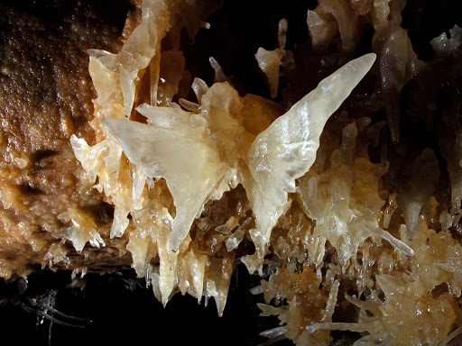
The Caverns of Sonora, a National Natural Landmark,[1] is a unique cave located 8 miles (13 km) west of the small city of Sonora, the seat of Sutton County, Texas. It is a world-class cave because of its stunning array of calcite crystal formations, especially helictites. These helictites are found in extreme abundance, often with a rare purity and complexity. One formation is so densely packed with them, it has been dubbed the "snake pit". The founder of the National Speleological Society, Bill Stephenson, said of the cave after his first visit: "This is the most indescribably beautiful cave in the world, its beauty cannot be exaggerated, not even by a Texan."[2]
History

The first quarter-mile of the cave was known to local ranch-hands by the early 1900s. It was known by the name Mayfield Cave, after the landowner, Stanley Mayfield.[3] In 1955, the landowner gave permission to four cavers from Dallas, who discovered a further seven miles, including what are now considered the most scenic areas.[3] The cave has been operated commercially by the Mayfield family since July 16, 1960.[4] Today, 2 mi (3.2 km) of trail have been developed from the 7 mi (11 km) of explored cave. The development of the trails was done by Jack Burch, starting in 1959[4] and completing in 1979. Burch revolutionized cavern development worldwide with his "conservation through commercialization" approach to the project.
The cave is formed in 100-million-year-old (Cretaceous) Segovia Limestone, of the Edwards Group. The formation of the cave itself probably occurred between 1.5 and 5 million years ago. The cave is formed primarily along a fault, which allowed gases to rise up from depths of around 1.5 mi (2.4 km) to then depths of about 300 ft (91 m). At this depth, the gases mixed with water in the aquifer. The resulting highly acidic water dissolved out the limestone, forming the cave. Between 1 and 3 million years ago, the water drained from the cave. The famous mineral formations, known as speleothems, all formed after the water drained from the cave.
The cave's most famous formation was the butterfly. It was the only known formation like it in the world. It was formed by two fishtail helictite growths that share the same attachment point of the cave wall. In November, 2006, about a third of the right wing was broken off of the formation.[5]
References
- ↑ "Caverns of Sonora; National Natural Landmark". National Park Service. Retrieved March 17, 2011.
- ↑ "The Caverns of Sonora". Retrieved February 12, 2009.
- 1 2 Pittman, Blair (1999). Texas Caves. Texas A&M University Press. p. 122. ISBN 0-89096-849-7.
- 1 2 "Cave History". Caverns of Sonora. Retrieved February 12, 2009.
- ↑ "Caverns' Butterfly damaged". San Angelo Standard-Times. Retrieved January 30, 2015.
External links
- Cavernsofsonora.com: Caverns of Sonora website
- High Res picture of the butterfly formation
- Mysteries at the Caverns of Sonora — San Angelo LIVE!