Cefnpennar

Coordinates: 51°41′49″N 3°23′38″W / 51.697°N 3.394°W
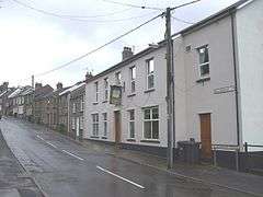
Cefnpennar also known as Cefn Pennar is a small rural hamlet north of the coal mining town of Mountain Ash, Rhondda Cynon Taff, in Wales. The village that has been in existence since at least 1870 [1] is still part of the Aberdare, Rhondda Cynon Taff Parish.[2] It is approximately 1 mile from Mountain Ash town centre and buses run daily (every 30 minutes according to DirectTransport.co.uk 2013). It has a number of streets including: Blackberry Place, Cefnpennar Road, Greenfield Terrace, Llwynbedw, The Avenue & Toncoch Terrace .
Facilities
It has a convenience store / village shop, pub, chapel, parish church and its own golf course named: Mountain Ash Golf Club (Welsh: Clwb Golff Aberpennar) as well as a children's playground and near opposite of which are a pair of bottle recycling banks. The local convenience store also serves as the villages post office . Much of the housing in the area are two to three bedroomed properties.
The nearest schools are Glenboi Primary School in Fernhill (1.2 km)Caegarw Primary School (1.8 km) for primary education and Mountain Ash Comprehensive school (1 km) for secondary education. There is also a girls only school called Aberdare Girls Upper Comprehensive nearby.
The nearest hospital is Ysbyty Cwm Cynon just over 1 km away.
The nearest train station is Fernhill just over 1 km away.[3]
Cefnpennar benefits from the Cefnpennar & District Welfare Association whom maintain a significant presence in the area.
Geography
The village is in the Cynon valley of the South Wales Valleys and as such the nearest river is the Cynon river with the Nant Pennar tributary running through the village. It is reported to be at least one mile above sea level [4] with low levels of light pollution.
It is surrounded on all sides by deciduous or mixed woodland.
As the village is on the east side of the Cynon river, sunlight focuses on the region in the evening rather than the morning.
External links
- Cefnpennar & District Welfare Association
- Welsh Coal Mines - research the local pit history
- www.geograph.co.uk : photos of Cefnpennar and surrounding area
References
- ↑ Wilson, John Marius. (2013). A Vision of Britain through Time. Available: http://www.visionofbritain.org.uk/place/23264. Last accessed 19 April 2013.
- ↑ Kain, R.J.P., Oliver, R.R.. (2001). Aberdare Parish Map part 68. Available: http://www.genuki.org.uk/big/wal/GLA/Aberdare/ParishMap.html. Last accessed 19 April 2013.
- ↑ https://maps.google.co.uk/maps?q=Cefn+Pennar&hl=en&t=h&hnear=Cefnpennar,+Rhondda+Cynon+Taff,+United+Kingdom&z=15
- ↑ TheEvilOne. (2010). Hello From Cefnpennar!!! . Available: http://stargazerslounge.com/topic/72374-hello-from-cefnpennar/. Last accessed 19 April 2013.