Cerro Ciento
| Cerro Ciento | |
|---|---|
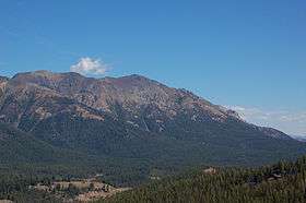 Cerro Ciento is the highest peak on the left side of the photo | |
| Highest point | |
| Elevation | 11,154 ft (3,400 m) [1] |
| Prominence | 554 ft (169 m) [1] |
| Coordinates | 43°51′49″N 114°35′00″W / 43.8635°N 114.5834°WCoordinates: 43°51′49″N 114°35′00″W / 43.8635°N 114.5834°W |
| Geography | |
| Parent range | Boulder Mountains |
| Topo map | USGS Easley Hot Springs |
| Climbing | |
| Easiest route | Simple scramble, class 2 |

Cerro Ciento, at 11,154 feet (3,400 m) above sea level is the tenth highest peak in the Boulder Mountains of Idaho. Located in the Hemingway–Boulders Wilderness of Sawtooth National Recreation Area on the border of Blaine and Custer counties, Cerro Ciento is about 0.8 miles (1,300 m) north of Easley Peak. Cerro Ciento is the 80th highest peak in Idaho.[2][3]
The easiest route is an off-trail class 2 scramble from the end of the Spring Creek Road, which can be accessed from Idaho State Highway 75. The peak is easily visible from the highway and Galena Summit.[2][4][5]
References
- 1 2 "Cerro Ciento, Idaho". Peakbagger.com. Retrieved December 19, 2012.
- 1 2 Sawtooth National Forest (Map) (1998 ed.). Sawtooth National Forest, U.S. Forest Service.
- ↑ "The 100 Highest Peak". Idaho: A Climbing Guide. Retrieved December 19, 2012.
- ↑ "Cerro Ciento". Idaho Summits. Retrieved December 19, 2012.
- ↑ "Cerro Ciento". SummitPost.org. Retrieved December 19, 2012.
This article is issued from Wikipedia - version of the 12/21/2015. The text is available under the Creative Commons Attribution/Share Alike but additional terms may apply for the media files.