Santa Lucía Hill
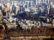
Santa Lucía Hill (Spanish: Cerro Santa Lucía) is a small hill in the centre of Santiago, Chile. It is situated between Alameda del Libertador Bernardo O'Higgins in the south, Santa Lucía Street in the west and Victoria Subercaseaux on the east. An adjacent metro station is named after it. The hill has an altitude of 629 m and a height of 69 m over the surrounding area. The hill is the remnant of a volcano 15 million years old.[1]
The hill comprises a 65,300 square metre park[2] adorned with ornate facades, stairways and fountains. At the highest point there is a viewpoint popular with tourists visiting the city.
History
It was originally called Huelén by the pre-colonization inhabitants. However, the current name comes from the day in which Pedro de Valdivia conquered the hill, on December 13, 1541. That day celebrates "Santa Lucía."
Its first use by its conquerors was as a point of reconnaissance, or a lookout in the years of the Conquista (1541).
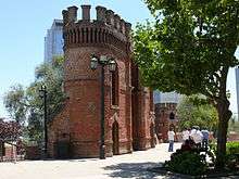
In 1816, the Brigadier of the Royal Engineers Manuel Olaguer Feliú, proceeded to draw and build on the Santa Lucía Hill, two forts or castles, one north and another south of the hill, built of stone and lime and able to put eight or twelve cannons each. Besides, Olaguer Feliú drew and built an outbuilding for ammunition depot and to house the garrison.[3]
On one side of the hill, Fort Hidalgo was finished in 1820 as a defensive point. On the other side, the hillside terrain was used as a "cemetery for the dissidents", people who did not follow the then-official Roman Catholic faith, or were considered otherwise unworthy of burial at hallowed grounds. However, the remains buried in the hillside under this fashion were eventually transferred to a secluded section of the General Cemetery, before said cemetery, in turn, was opened to all burials regardless of creed or social condition.
In 1872 Benjamín Vicuña Mackenna decided to conduct a dramatic change to the urban atmosphere of the city of Santiago, among his many works aimed to improve the city, and thus initiated an extensive remodelation of the hill. The works of 1872 consisted of a road which crossed the hill, which at the top accessed a chapel which he also built there, illuminated by the then-novel means of gas. The rest of the hill contains a park with fountains and lookouts. The actual hill is watered by a sophisticated irrigation system. The now iconic yellow and white facade is also a product of Vicuña Mackenna's remodelation.
Vicuña Mackenna was assisted in realizing his designs by the architect Manuel Aldunate, the constructor Enrique Henes, and the stonecutter Andrés Staimbuck.
A few years ago, Santa Lucía hill received an improvement in its illumination system and protections. Also, Fort Hidalgo was restored and reopened to the public. Traditionally, a cannon shot is fired exactly at noon.
Curiosity
Located in Santa Lucía Hill there is a monument which consists of a 2 m high stone carved with a paragraph extracted from the text that Pedro de Valdivia sent to the Emperor Carlos V describing the features of the new land conquered.
Inside Santa Lucía Hill
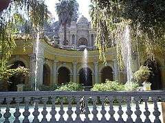
 Fountain in "Patio Circular".
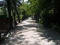 Old path of the Train.
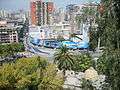 Outlook from Santa Lucía towards Alameda.
 Outlook of the Pedro de Valdivia square.
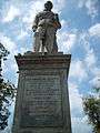 Monument of Pedro de Valdivia
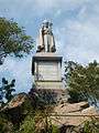 Monument of archbishop Manuel Vicuña Larrain.
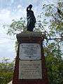 Monument dedicated, in turn, to "those disowned both by Heaven and Earth, buried here for half a century", and to Protestants in particular, "buried here for their faith in Christ".
 A list with the name of people who founded the city of Santiago during the first cabildo abierto.
References
- ↑ http://www.letsgochile.com/locations/central-zone/rm/cerro-santa-lucia Cerro Santa Lucia
- ↑ http://www.educarchile.cl/Portal.Base/Web/VerContenido.aspx?ID=183385
- ↑ Barros Arana, Diego (1889). Historia General de Chile (in Spanish). X. Santiago de Chile: Rafael Jover. pp. 241–243.
External links
| Wikimedia Commons has media related to Santa Lucía Hill. |
Coordinates: 33°26′24″S 70°38′38″W / 33.440°S 70.644°W