Chachas District
| Chachas | |
|---|---|
| District | |
|
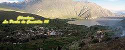
The town Chachas and Chachas Lake | |
| Country |
|
| Region | Arequipa |
| Province | Castilla |
| Capital | Chachas |
| Government | |
| • Mayor | Mario Cecilio Huayhua Funes |
| Area | |
| • Total | 1,190.49 km2 (459.65 sq mi) |
| Elevation | 3,055 m (10,023 ft) |
| Population (2005 census) | |
| • Total | 1,992 |
| • Density | 1.7/km2 (4.3/sq mi) |
| Time zone | PET (UTC-5) |
| UBIGEO | 040404 |
Chachas District is one of fourteen districts of the province Castilla in Peru.[1]
Geography
The Chila mountain range traverses the district. One of the highest mountains of the district is Chila at 5,654 m (18,550 ft) above sea level. Other mountains are listed below:[2]
- Apachita
- Asiruta
- Asnu Wañusqa
- Challwani
- Chinchun
- Chuqi Pirwa
- Chila
- Chila Pilluni
- Ch'uwañuma
- Ikma
- Janq'u Qala
- Kuntur Sinqa
- Kunturkhacha
- Pilluni
- Puka Mawras
- Phusuqu
- Qallwa
- Q'asiri
- Q'illu Q'illu
- Sama Q'asa
- Sani
- Sawsi
- Sirani
- Sulimana
- Sulluku Llawa
- Sunqu
- Tiklla
- Tiklla (Qaqamayu)
- Tuqlla Tuqlla
- Waman Quri
- Wamanripayuq
- Wanqa
- Waña Q'awa
- Waylla Tarpuna
- Wayllayuq
- Wayta
- Wayta Kuntur Sinqa
- Waywa Wawa
- Willkani
- Yana Qaqa
- Yuraq Q'asa
Machuqucha is the largest lake of the district. It lies on the border with the Orcopampa District.
See also
References
- ↑ (Spanish) Instituto Nacional de Estadística e Informática. Banco de Información Distrital Archived April 23, 2008, at the Wayback Machine.. Retrieved April 11, 2008.
- ↑ escale.minedu.gob.pe - UGEL maps of the Caylloma Province 1 and 2 (Arequipa Region)
Coordinates: 15°30′06″S 72°16′19″W / 15.5017°S 72.2719°W
This article is issued from Wikipedia - version of the 11/18/2016. The text is available under the Creative Commons Attribution/Share Alike but additional terms may apply for the media files.