Chanchamayo Province
| Chanchamayo | |||
|---|---|---|---|
| Province | |||
|
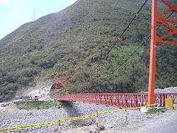
A bridge in the San Ramón District | |||
| |||
| Country | Peru | ||
| Region | Junín | ||
| Capital | La Merced | ||
| Government | |||
| • Mayor | Hung Won Jung | ||
| Area | |||
| • Total | 4,723.4 km2 (1,823.7 sq mi) | ||
| Population (2002 estimate) | |||
| • Total | 142,127 | ||
| • Density | 30/km2 (78/sq mi) | ||
| Website | http://www.munichanchamayo.gob.pe/ | ||

Chanchamayo (in hispanicized spelling) or Chanchamayu (Quechua chanchay to walk and leap about, to walk quickly and confused, chancha chancha to walk quickly and irregularly, shancha a kind of bird, mayu river)[1][2] is a province in northern Junín Region, in central Peru.
The name of the province derives from the river Chanchamayu, whose source is in the Andean Sierra and flows northwards becoming the Perené River.
The province has an estimated population of 142,127, half of whom live in the provincial capital, La Merced. Another important town in the province is San Ramón.
The Chanchamayo province is famous for citrus production and quality coffee growing.
History
The first inhabitants of this territory were the Yanesha' people and Ashaninkas. The first reported European presence in the area dates back to 1635, when Franciscan Fray Juan Jerónimo Jiménez founded the settlement of San Buena Ventura de Quimiri which was three kilometres (2 mi) away from present-day Chanchamayo.
Political division

The province is divided into six districts (Spanish: distritos, singular: distrito), each of which is headed by a mayor (alcalde). The districts, with their capitals in parenthesis, are:
- Chanchamayo (Chanchamayo)
- San Luis de Shuaro (San Luis de Shuaro)
- Perené (Perené)
- Pichanaqui (Bajo Pichanaqui)
- San Ramón (San Ramón)
- Vitoc (Pucará)
See also
References
| |
|---|---|
Coordinates: 11°03′16″S 75°19′45″W / 11.054387°S 75.329036°W