Charlotte Street, Brisbane
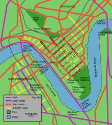
Charlotte Street is a road in the central business district of Brisbane, Queensland, Australia. The street is one of a number that were named after female queens and princesses of the royal family shortly after the penal colony was settled. Mary Street runs parallel to the south and Elizabeth Street is the next street to the north.
The one-directional road begins at a T-intersection where Creek Street becomes Eagle Street, close to the Brisbane River. Charlotte Street ends at another T-intersection with George Street. Here lies the 111 George Street tower containing mostly government offices.
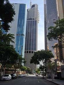
Charlotte Towers and Festival Towers are two tall residential buildings in Charlotte Street. The Elizabeth Arcade, St Stephens Cathedral, Comalco Place and The Pancake Manor are some of the other notable buildings located on Charlotte Street.
A number of multi-storey car parks have been built on the road. A police station once located on the Queen Street Mall was transferred to Charlotte Street. The iconic Victory Hotel, also on Charlotte Street, closed on 27 July 2008 after a fire destroyed the premises.[1] It has since re-opened in its original form.
Heritage listings
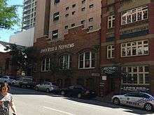

Charlotte Street has a number of heritage-listed sites, including:
- 10 Charlotte Street: former St Luke's Church of England, now The Pancake Manor[2]
- 26 & 36 Charlotte Street: John Reid and Nephews Building facade[3]
- 40 Charlotte Street: John Mills Himself Building[4]
- 42 Charlotte Street: George Weston and Sons Workshop[5]
- 120 Charlotte Street: Pan Australia House facade[6]
- 139 - 145 Charlotte Street: Charlotte House[7]
- 163 Charlotte Street: Walter Reid Building facade[8]
- 168 Charlotte Street: F.H. Faulding Warehouse[9]
- 172 Charlotte Street: St Stephens School[10]
- Sections of Albert St, George St, William St, North Quay, Queen's Wharf Rd: Early Streets of Brisbane (incorporating land now on Charlotte Street)[11]
- 110 George Street and 84 William Street: the former Government Printing Office[12]
Lost heritage includes:
- Brisbane Festival Hall (formerly Brisbane Stadium) on the southern corner with Albert Street
Major intersections
- George Street
- Albert Street
- Edward Street
- Creek Street / Eagle Street
See also
References
- ↑ Simon O'Brien (14 August 2008). "Victory patrons call for rise from the ashes". Brisbane Times. Retrieved 10 September 2008.
- ↑ "Pancake Manor (entry 600083)". Queensland Heritage Register. Queensland Heritage Council. Retrieved 19 June 2013.
- ↑ "John Reid and Nephews Building facade". Brisbane Heritage Register. Brisbane City Council. Retrieved 10 March 2015.
- ↑ "John Mills Himself Building (entry 600084)". Queensland Heritage Register. Queensland Heritage Council. Retrieved 19 June 2013.
- ↑ "George Weston and Sons Workshop". Brisbane Heritage Register. Brisbane City Council. Retrieved 10 March 2015.
- ↑ "Pan Australia House facade". Brisbane Heritage Register. Brisbane City Council. Retrieved 10 March 2015.
- ↑ "Charlotte House (entry 600082)". Queensland Heritage Register. Queensland Heritage Council. Retrieved 19 June 2013.
- ↑ "Walter Reid Building facade". Brisbane Heritage Register. Brisbane City Council. Retrieved 10 March 2015.
- ↑ "F.H. Faulding Warehouse". Brisbane Heritage Register. Brisbane City Council. Retrieved 10 March 2015.
- ↑ "St Stephens School (entry 600106)". Queensland Heritage Register. Queensland Heritage Council. Retrieved 19 June 2013.
- ↑ "Early Streets of Brisbane (entry 700011)". Queensland Heritage Register. Queensland Heritage Council. Retrieved 19 June 2013.
- ↑ "Government Printing Office (former) (entry 600114)". Queensland Heritage Register. Queensland Heritage Council. Retrieved 19 June 2013.
Coordinates: 27°28′14.54″S 153°01′38.40″E / 27.4707056°S 153.0273333°E