Charsianon
| Charsianon Χαρσιανόν, θέμα Χαρσιανοῦ | |||||
| Theme of the Byzantine Empire | |||||
| |||||
 | |||||
| Capital | Charsianon (at first), Caesarea | ||||
| Historical era | Middle Ages | ||||
| • | Establishment as a theme | 863–873 | |||
| • | Fall to the Seljuks | after ca. 1072/3 | |||
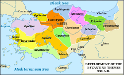
Charsianon (Greek: Χαρσιανόν) was the name of a Byzantine fortress and the corresponding theme (a military-civilian province) in the region of Cappadocia in central Anatolia (modern Turkey). It center was first in Charsianon (its ruins are found in Muşalikalesi village of Akdağmadeni district in Yozgat Province), later in Caesarea.
History
The fortress of Charsianon (Greek: Χαρσιανόν κάστρον, Charsianon kastron; Arabic: Qal'e-i Ḥarsanōs) is first mentioned in 638, during the first wave of the Muslim conquests, and was allegedly named after a general of Justinian I named Charsios. The Arabs first seized it in 730, and it remained a hotly contested stronghold during the next century of Byzantine–Arab warfare.[1] In the early 9th century, the fortress became the center of a kleisoura, a separately administered fortified frontier district. Sometime between 863 and 873, it was raised to the status of a full theme, augmented by territory from the neighboring Bucellarian, Armeniac and Cappadocian themes.[1][2] It ranked in the middle tier of themes, with its governing strategos receiving an annual salary of 20 pounds of gold and commanding, according to Arab sources, 4,000 men and four fortresses.[1]
In the 10th century, the theme of Charsianon became a major stronghold of the landed military aristocracy, with the great clans of Argyros and Maleinos having their homes and estates there. After 1045, a large number of Armenians, including the former king Gagik II (r. 1042–1045), were settled there, leading to friction with the local Greeks. The theme was lost to the Seljuk Turks following the Battle of Manzikert in 1071 and given to Danishmendids.[1] Gagik II is attested as the last doux of Charsianon in 1072–1073.[2]
References
- 1 2 3 4 Kazhdan 1991, p. 415.
- 1 2 McGeer, Nesbitt & Oikonomides 2001, p. 107.
Sources
- Kazhdan, Alexander Petrovich, ed. (1991). The Oxford Dictionary of Byzantium. New York, New York and Oxford, United Kingdom: Oxford University Press. ISBN 978-0-19-504652-6.
- McGeer, Eric; Nesbitt, John W.; Oikonomides, Nicolas, eds. (2001). Catalogue of Byzantine Seals at Dumbarton Oaks and in the Fogg Museum of Art, Volume 4: The East. Washington, District of Columbia: Dumbarton Oaks Research Library and Collection. ISBN 0-88402-282-X.
Coordinates: 39°44′25″N 35°50′10″E / 39.740217°N 35.836142°E