Chart datum
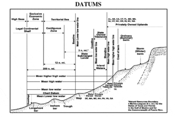
A chart datum is the level of water that charted depths displayed on a nautical chart are measured from. A chart datum is generally a tidal datum; that is, a datum derived from some phase of the tide.[1] Common chart datums are lowest astronomical tide[1] and mean lower low water.
A chart datum is a vertical datum and must not be confused with the horizontal datum for the chart.
Lowest astronomical tide
Many national charting agencies, including the United Kingdom Hydrographic Office and the Australian Hydrographic Service, use the Lowest Astronomical Tide (LAT) - the height of the water at the lowest possible theoretical tide - to define chart datums. LAT is the lowest levels which can be predicted to occur under average meteorological conditions.[2]
One advantage of using LAT is that all predicted tidal heights must then be positive (or zero) avoiding possible ambiguity and the need to explicitly state sign. Calculation of the LAT only allows for gravitational effects so lower tides may occur in practice due to other factors (e.g. meteorological effects such as high pressure systems).
Mean lower low water
The United States' National Oceanic and Atmospheric Administration uses mean lower low water (MLLW), which is the average height of the lowest tide recorded at a tide station each day during the recording period (the National Tidal Datum Epoch[3] - a 19 year period). MLLW is only a mean, so some tidal levels may be negative relative to MLLW, see also Mean low water spring.
Charts and tables
Charted depths and drying heights on nautical charts are given relative to chart datum. Some height values on charts, such as vertical clearances under bridges or overhead wires, may be referenced to a different vertical datum, such as Mean High Water Springs or Highest Astronomical Tide (for "HAT" see "tidal range").
Tide tables give the height of the tide above a chart datum making it feasible to calculate the depth of water at a given point and at a given time by adding the charted depth to the height of the tide. One may calculate whether an area that dries is under water by subtracting the drying height from the [given] height calculated from the Tide table.
Using charts and tables not based on the same datum can result in incorrect calculation of water depths. Be wary. Always confirm compatibility.
Chart Datum and GNSS
In recent years national hydrographic agencies have spearheaded developments to establish Chart Datum with respect to the GRS 80 reference ellipsoid, thus enabling direct compatibility with GNSS positioning. Examples of this include VORF[4] for the UKHO and Bathyelli[5] for SHOM.
References
- 1 2 Australian Bureau of Meteorology National Tide Centre Glossary http://www.bom.gov.au/oceanography/projects/ntc/NTC_glossary.pdf (retrieved 30 April 2013)
- ↑ CIRIA (1996). Beach management manual. CIRIA Report 153.
- ↑ "Tidal Datums". tidesandcurrents.noaa.gov.
- ↑ "Vertical Offshore Reference Frames (VORF)". UCL. Retrieved 2016-11-29.
- ↑ "SHOM BATHYELLI : le nouveau produit du zéro hydrographique référencé à l'ellipsoïde sur data.shom.fr". SHOM. Retrieved 2016-11-29.
- Australian Tides Manual SP9 V4.1, Australian Intergovernmental Committee on Surveying and Mapping, Permanent Committee on Tides and Mean Sea Level http://www.icsm.gov.au/tides/SP9_Australian_Tides_Manual_V4.1.pdf