Cheboygan County Airport
| Cheboygan County Airport | |||||||||||||||
|---|---|---|---|---|---|---|---|---|---|---|---|---|---|---|---|
| IATA: none – ICAO: KSLH – FAA LID: SLH | |||||||||||||||
| Summary | |||||||||||||||
| Airport type | Public | ||||||||||||||
| Owner | Cheboygan Airport Authority | ||||||||||||||
| Serves | Cheboygan, Michigan | ||||||||||||||
| Elevation AMSL | 640 ft / 195 m | ||||||||||||||
| Coordinates | 45°39′13″N 084°31′09″W / 45.65361°N 84.51917°W | ||||||||||||||
| Website | CheboyganAirport.com | ||||||||||||||
| Map | |||||||||||||||
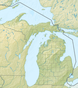
 SLH  SLH Location of airport in Michigan/United States | |||||||||||||||
| Runways | |||||||||||||||
| |||||||||||||||
| Statistics (2007) | |||||||||||||||
| |||||||||||||||
Cheboygan County Airport (ICAO: KSLH, FAA LID: SLH) is a public use airport located two nautical miles (3.7 km) west of the central business district of Cheboygan, a city in Cheboygan County, Michigan, United States. It is owned by the Cheboygan Airport Authority.[1] It is included in the Federal Aviation Administration (FAA) National Plan of Integrated Airport Systems for 2017–2021, in which it is categorized as a basic general aviation facility.[2] The airport is accessible from Levering Road and is close to US Highway 23.
Although many U.S. airports use the same three-letter location identifier for the FAA and IATA, this airport is assigned SLH by the FAA and no designation from the IATA[3] (which assigned SLH to Sola Airport on Vanua Lava, one of the Banks Islands, in Torba Province, Vanuatu[4]).
Facilities and aircraft
Cheboygan County Airport covers an area of 350 acres (140 ha) at an elevation of 639 feet (195 m) above mean sea level. It has two runways: 10/28 is 4,005 by 75 feet (1,221 x 23 m) with an asphalt pavement and 16/34 is 1,600 by 75 feet (488 x 23 m) with a turf surface.[1]
For the 12-month period ending December 31, 2007, the airport had 6,854 general aviation aircraft operations, an average of 18 per day. At that time there were 18 aircraft based at this airport: 88.9% single-engine, 5.6% multi-engine and 5.6% ultralight.[1]
The airport is staffed between 8:30 AM and 4:30 PM.
References
- 1 2 3 4 FAA Airport Master Record for SLH (Form 5010 PDF). Federal Aviation Administration. Effective 3 June 2010.
- ↑ "List of NPIAS Airports" (PDF). FAA.gov. Federal Aviation Administration. 21 October 2016. Retrieved 25 November 2016.
- ↑ "Cheboygan, Michigan - Cheboygan County Airport (ICAO: KSLH, FAA: SLH)". Great Circle Mapper. Retrieved 20 May 2010.
- ↑ "Sola, Vanua Lava Island, Banks Islands, Torba, Vanuatu (IATA: SLH, ICAO: NVSC)". Great Circle Mapper. Retrieved 20 May 2010.
External links
- Cheboygan County Airport, official site
- "Cheboygan County (SLH)" (PDF). (39.0 KB) at the Michigan DOT Airport Directory
- Aerial photo as of 28 April 1998 from USGS The National Map
- FAA Terminal Procedures for SLH, effective November 10, 2016
- Resources for this airport:
- FAA airport information for SLH
- AirNav airport information for KSLH
- FlightAware airport information and live flight tracker
- NOAA/NWS latest weather observations
- SkyVector aeronautical chart, Terminal Procedures