Chemin de la Mâture
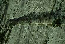
Coordinates: 42°53′17.7″N 0°33′38″W / 42.888250°N 0.56056°W The Chemin de la Mâture is a 1,200-metre (3,900 ft) path carved into a sheer rock face rising over 200 metres (660 ft) above the Aspe River valley, in the French Pyrenees mountains. Completed by the engineer Paul-Marie Leroy in 1772,[1] the Chemin de la Mâture (literally "The Mast Road") was originally created to transport timber from the nearby Pacq forest to be used in constructing French naval vessels. The path has since been incorporated into the GR 10, a long-distance footpath running along the Pyrenees from the Atlantic to the Mediterranean.
The Chemin de la Mâture lies near the village of Etsaut, in the department of Pyrénées-Atlantiques. The area is popular for rock climbing.
External links
Notes
- ↑ LEROY, P.-M.: Mémoire sur les travaux qui ont rapport à l'exploitation de la mâture dans les Pyrénées, Adret éditions 1776 (by way of http://ecomusee.vallee-aspe.com/mature.pdf).
- Translated in part from the article of the same name on French Wikipedia