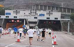
Cheung Tsing Tunnel
| |
|---|---|
| Part of Route 3 | |
| Route information | |
| Maintained by Highways Department | |
| Length: | 1.6 km (1.0 mi) |
| History: | Built 1997 |
| Major junctions | |
| East end: | Tsing Yi |
| West end: | Tsing Yi |
| Highway system | |
| Hong Kong Strategic Route and Exit Number System | |
| Cheung Tsing Tunnel | |||||||||||
|
| |||||||||||
| Traditional Chinese | 長青隧道 | ||||||||||
|---|---|---|---|---|---|---|---|---|---|---|---|
| Simplified Chinese | 长青隧道 | ||||||||||
| |||||||||||

Cheung Tsing Tunnel, also spelled Cheung Ching Tunnel, is a dual tube 3-lane tunnel on Tsing Yi Island, Hong Kong. It is part of Tsing Kwai Highway of Route 3. Its east end connects to Rambler Channel Bridge and west Cheung Tsing Highway. The tunnel was opened on 1997-05-22 and is the second toll-free tunnel in Hong Kong. Its length is about 1.6 kilometres.
Construction
The tunnel was given the name "Cheung Ching" (長青) because it is beneath Cheung Ching Estate, the first public housing estate on the island.
Construction through the granite of Tsing Yi Peak required explosives to get through the hardness of the hill. To prevent dislodging of rocks and buildings on the surface slopes the rocks were reinforced by concrete and steel. Although the tunnel used explosives in its construction, boring was more used as the primary digging procedure.
Management
The tunnel was managed by Tsing Ma Management Limited under Tsing Ma Control Area, along with Tsing Ma Bridge, Kap Shui Mun Bridge, Ting Kau Bridge, Rambler Channel Bridge, North Lantau Highway and Tsing Kwai Highway.
The traffic of the tunnel is monitored in the buildings at both end, namely East Portal and West Portal Buildings.
External links
| Wikimedia Commons has media related to Cheung Tsing Tunnel. |
| Preceded by Cheung Tsing Bridge |
Hong Kong Route 3 Cheung Tsing Tunnel |
Succeeded by Cheung Tsing Highway |
Coordinates: 22°20′56″N 114°06′43″E / 22.34877°N 114.11188°E
