Chiapas Depression dry forests
| Chiapas Depression dry forests | |
|---|---|
|
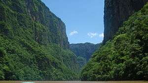
Chiapas Depression dry forests in Sumidero Canyon | |
| Ecology | |
| Biome | Tropical and subtropical dry broadleaf forests |
| Geography | |
| Area | 13,900 km2 (5,400 sq mi) |
| Countries | Mexico (Southern) and Guatemala |
| Conservation | |
| Conservation status | Critical/Threatened[1] |
The Chiapas Depression dry forests form one of the ecoregions that belong to the tropical and subtropical dry broadleaf forests biome, as defined by the World Wildlife Fund, in northwestern Central America.
Geography
This ecoregion is located in the central Chiapas Depression, the central depression of the eastern Sierra Madre de Chiapas, in Chiapas state of Mexico and into northwestern Guatemala.
It covers an area of around 13,900 km2.[2] It lies at an altitude of 420–800 metres (1,380–2,620 ft).
Ecology
The Chiapas Depression dry forests ecoregion has a hot, dry climate.
Its biodiversity is high, with about 980 plant species, and includes 40% of the endemic species of dry ecosystems found in Mexico.[2] It also forms a corridor that connects two major biogeographic region, the Gulf of Mexico on the east and the Pacific in the west.
Conservation threats
The ecoregion has been seriously threatened by cattle grazing, which is the main cause of its destruction, along with the effects of logging and the expansion of the agricultural frontier.[2]
See also
- Tropical and subtropical dry broadleaf forests ecoregions
References
- ↑ "Chiapas Depression dry forests". Terrestrial Ecoregions. World Wildlife Fund. Retrieved 2013-08-24.
- 1 2 3 "Chiapas Depression dry forests". Fondo Mundial para la Naturaleza. Retrieved 2013-08-21.
External links
- "Chiapas Depression dry forests". Terrestrial Ecoregions. World Wildlife Fund.
- World Wildlife Fund (2001). "Chiapas Depression dry forests". WildWorld Ecoregion Profile. National Geographic Society. Archived from the original on 2010-03-08.