Chichagof Harbor
| Chichagof Harbor[1] | |
|---|---|
| Chichagof Bay, Tschitschagoff Harbor | |
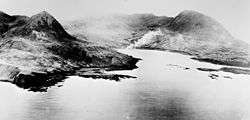 Aerial photo of Chichagof harbor on Attu island, Alaska (USA), during the Battle of Attu, 11 to 30 May 1943. | |
|
Lua error in Module:Location_map at line 442: Unable to find the specified location map definition. Neither "Module:Location map/data/Gray alaska.svg" nor "Template:Location map Gray alaska.svg" exists. Location of Chichagof Harbor in Alaska | |
| Location |
Attu Island |
| Coordinates | 52°55′48.24″N 173°14′41.21″E / 52.9300667°N 173.2447806°ECoordinates: 52°55′48.24″N 173°14′41.21″E / 52.9300667°N 173.2447806°E |
| Type | Bay |
| Etymology | Vasily Chichagov |
| Ocean/sea sources | Bering Sea |
| Average depth | 2-4 fathoms |
Chichagof Harbor is an inlet on the northeast coast of the island of Attu in the Aleutian Islands in Alaska.[2] It is named after Russian Admiral and polar explorer Vasily Chichagov. It is the location of the Aleut village served by an American pastor and his wife. It was also where some heavy fighting took place during the recapture of the island from the Japanese during the Battle of Attu in World War II and afterward was the site of Battery B 42nd Coast Artillery Battalion.
Notes
- ↑ "Map of Chichagof Harbor in Aleutians West (CA), Alaska". Cartographic.info. Retrieved March 20, 2015.
- ↑ Merriam-Webster's Geographical Dictionary, Third Edition, p. 243.
References
- Merriam-Webster's Geographical Dictionary, Third Edition. Springfield, Massachusetts: Merriam-Webster, Incorporated, 1997. ISBN 0-87779-546-0.
This article is issued from Wikipedia - version of the 3/20/2015. The text is available under the Creative Commons Attribution/Share Alike but additional terms may apply for the media files.