Chikurachki
| Chikurachki | |
|---|---|
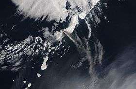 Eruption of Chikurachki, 22 April 2003 | |
| Highest point | |
| Elevation | 1,816 m (5,958 ft) [1] |
| Prominence | 1,816 m (5,958 ft) [1] |
| Listing | Ultra |
| Coordinates | 50°19′24″N 155°27′39″E / 50.32333°N 155.46083°ECoordinates: 50°19′24″N 155°27′39″E / 50.32333°N 155.46083°E [1] |
| Geography | |
 Chikurachki | |
| Geology | |
| Mountain type | Stratovolcano |
| Last eruption | July 2016 (ongoing) |
Chikurachki (Russian: Чикурачки; Japanese: 千倉岳, Chikura-dake) is the highest volcano on Paramushir Island in the northern Kuril Islands, is actually a relatively small cone constructed on a high Pleistocene volcanic edifice. Oxidized andesitic scoria deposits covering the upper part of the young cone give it a distinctive red color. Lava flows from 1,816-metre (5,958 ft) high Chikurachki reached the sea and form capes on the NW coast; several young lava flows also emerge from beneath the scoria blanket on the eastern flank.
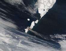
Eruption of Chikurachki, 13 May 2003
See also
Notes
- 1 2 3 "Russia: Kamchatka and the Russian Pacific Islands Ultra-Prominence Page" Peaklist.org. Retrieved 2011-11-27.
References
- Siebert L, Simkin T (2002-). Volcanoes of the World: an Illustrated Catalog of Holocene Volcanoes and their Eruptions. Smithsonian Institution, Global Volcanism Program Digital Information Series, GVP-3, (http://www.volcano.si.edu).
- "Chikurachki". Global Volcanism Program. Smithsonian Institution.
- "Vulkan Chikurachki, Russia" on Peakbagger
This article is issued from Wikipedia - version of the 7/28/2016. The text is available under the Creative Commons Attribution/Share Alike but additional terms may apply for the media files.