Chola Mountain
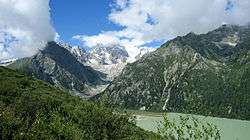
Chola Mountain or Trola Mountain、Chola Shan、Que'er Mountain、Que'er Shan (simplified Chinese: 雀儿山; traditional Chinese: 雀兒山; pinyin: Què'ér Shān) is a mountain range in western Sichuan Province,China. Chola or Trola is Tibetan name, which means the big bird's wing. The highest peak that shares the same name ( Tibetan name : Rongmai Angzha ) is 6,168 metres (20,236 ft). However, others claim, Chola is just another name for snow mountain, given by local Tibetans. The Chinese phonetic transliteration for Chola uses two characters: Que Er, and written so on official maps. Hence, many foreign guide books use the literal translation of the Chinese Characters: Sparrow. So, mistakenly Cola became "Bird Mountain".
Another view presented on the origin of "Chola" was given by Sir Richard Temple in the Proceedings of the Royal Geographical Society and monthly record of Geography, Volume 3, 1881. Lake Region of Sikkim, on the Frontier of Tibet, by Sir Richard Temple(p. 334). By the Royal Geographical Society (Great Britain). According to him, ...Tso is a common termination in Tibetan names, meaning water, and is sometimes pronounced tcho; in fact, Europeans cannot tell whether natives are saying tso or tcho. It means a lake. Nimyetso is Nimye Lake. In Tibetan, la means a pass, so that Chola, or Cho-la means lake-pass.
National Road G-317 crosses the mountain via Cho-La pass between Maniganggo and Dege, and the summit has a marker indicating 5050m asl (16568').
References
Lake Region of Sikkim, on the Frontier of Tibet, by Sir Richard Temple, Proceedings of the Royal Geographical Society and monthly record of Geography, Volume 3, 1881, (p. 334). By Royal Geographical Society (Great Britain)
Coordinates: 31°46′52″N 99°02′30″E / 31.78111°N 99.04167°E