Clifford, Herefordshire
| Clifford | |
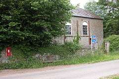 The Former Methodist Chapel in Clifford |
|
 Clifford |
|
| Population | 511 (2011 Census)[1] |
|---|---|
| OS grid reference | SO243457 |
| – London | 162 mi (261 km) |
| Civil parish | Clifford |
| Unitary authority | Herefordshire |
| Ceremonial county | Herefordshire |
| Region | West Midlands |
| Country | England |
| Sovereign state | United Kingdom |
| Post town | Hereford |
| Postcode district | HR3 |
| Dialling code | 01497 |
| Police | West Mercia |
| Fire | Hereford and Worcester |
| Ambulance | West Midlands |
| EU Parliament | West Midlands |
| UK Parliament | Hereford and South Herefordshire |
|
|
Coordinates: 52°06′17″N 3°06′09″W / 52.1047°N 3.1025°W
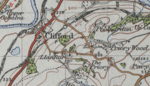
Clifford is a village and civil parish in Herefordshire, England, four miles to the north of Hay-on-Wye. It lies on the south bank of the River Wye, which here forms the border between Wales and England. Through the village runs the B4350 which is the main road.
The civil parish also includes the hamlets of Priory Wood and Hardwicke. There has been a fluctuation in population, the graph shows that the population was higher in the 2001 census, stating there was a population of 530[2] Newton Tump is the remains of a motte and bailey castle 3 miles southeast of the village.[3]
In the 1870s, Clifford was described as:
- "The village stands on the river Wye, adjacent to the Hereford and Brecon railway, 2 miles NNE of Hay; and has a post office under Hereford. The parish includes also part of Vowmine township. Acres, 6, 522. Real property, £6, 209. Pop., 895. Houses, 207. A castle was built here by W. Fitzosborne; became the seat of the Cliffords of Ugbrooke; and was the birthplace of Jane de Clifford, "Fair Rosamond, " the favourite of Henry II."[4]
The Village has a parish church which is dedicated to St. Mary. The church is made up of an ancient structure in a Norman style, and there are several monuments within the church.[5]
Population

The population graph shows an increase in population up until 1840 when the population of Clifford began to decrease. The movement of people away from rural areas in the early 19th century was due to technical advances and socio-economic changes leading to urban areas becoming more densely populated.[6] The technical advances meant that fewer people were needed in the agricultural industry, and this allowed people to move into towns and cities and begin to work for the labour industry.[6] Therefore, this continuous decrease in population resulted in an overall net decrease from 1801 to 2011.
Neighbourhood statistics show that from 2001 and 2011 there has been an overall decrease in population from 530[7] to 511 people,[8] although statistics show that there has been an increase in the ageing population from 287 people aged over 45 in 2001[7] to 296 people aged over 45 in 2011.[8]
Clifford castle
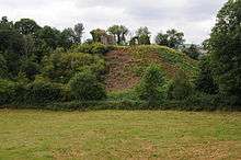
The ruins of the Norman castle of Clifford Castle are in the village.
Clifford Castle is a "traditional motte and bailey castle" which[9] stands next to the River Wye on the border between England and Wales, it "covers an area in excess of 4 acres".[10] The castle was founded by Earl William Fitz Osbern between the time of his being made Earl of Heredford in 1066 and his death in 1071.[11] "Clifford Castle is one of five castles mentioned in the Domesday Survey of 1086".[12] The castle is situated alongside a steep drop to the River Wye close by to a ford, therefore "this gave the site its later name, the cliff by the ford or Clifford".[11] Originally the castle was built to protect a settlement which was to be built around the same time as the castle, housing up to 200 families.[11] This settlement was the village of Clifford although it is now only a small village.
Clifford primary school

Clifford Primary School is a community school built in 1837 and situated in the rural area of Herefordshire, only 3 miles away from Hay-on-Wye as well as being close to the Black Mountains.[13] The school's Ofsted report from 2012 states that there are 71 children in attendance of the school from the age of 4 years old to 11 years old (Year R to Year 6); this report was carried out on 10 October and received a 'good' status.[14]
The school is interested in being eco-friendly, and due to a large amount of recycling and re-using the school has been given the Eco Schools Green Flag Award.[15]
Occupation
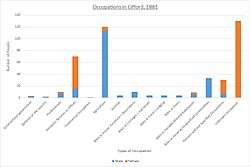
1881 occupations The 1881 occupations graph shows that males dominated the workforce with the agricultural industry as well as many other types of jobs including 'workers in house, furniture and decorations' and 'workers in dress'. Although women are perceived not to have a working life, they still dominated the 'domestic services or offices' working sector with a small minority of women appearing in the general/local government and professional line of works.

2011 occupations The 2011 Occupations graph shows a contrast in the types of jobs the villagers have. There is a significant increase in the amount of professional and office based jobs that are distributed around the villagers. There is a significant lower number of agricultural jobs, which may be due to the introduction of farming machinery meaning that there is less space for a large number of agricultural farmers.
The traditional building skills company The company focuses on providing high quality training to individuals as well as construction companies in working with historic structures. The company works with "The Construction Industry Training Board, The Stone Federation, The Institute of Carpenters and The National Heritage Training Group"[16] to help to provide the most high quality set of skills. The company offers a wide range of courses including stone-carving and woodcarving and the company has been running these courses now for 3 years.[17]
External links
![]() Media related to Clifford, Herefordshire at Wikimedia Commons
Media related to Clifford, Herefordshire at Wikimedia Commons
References
- ↑ "Civil Parish population 2011". Retrieved 29 October 2015.
- ↑ ONS: Neighbourhood Statistics 2001
- ↑ Herefordshire Through Time
- ↑ Wilson, John Marius (1870). Gazetteer of England and Wales. Edinburgh: A. Fullerton & Co. Retrieved 27 January 2015.
- ↑ "Clifford, Herefordshire – Extract from National Gazetteer, 1868". GENUKI. Colin Hinson. 2003. Retrieved 25 March 2015.
- 1 2 Maund, David; Phil, M (February 2008). "A Multidisciplinary Longitudinal Study of Population Trends and Migration in an area of the English-Welsh Borderland" (PDF). Moving-On From A Rural Parish: 2–9. Retrieved 25 March 2015.
- 1 2 "Age Structure, 2001 (KS02)". Office for national statistics. Retrieved 25 March 2015.
- 1 2 "Key figures for 2011 Census: Key Statistics". Office for national statistics. Retrieved 25 March 2015.
- ↑ Ross, David. "Clifford Castle". Britain Express. Retrieved 16 March 2015.
- ↑ "Clifford: Clifford Casle". Heredfordshire Through Time. 25 February 2013. Retrieved 19 March 2015.
covers an area in excess of 4 acres
- 1 2 3 Remfry, Paul (2009). "Clifford Castle". Castle of Wales. Retrieved 16 March 2015.
- ↑ "Clifford: Clifford Castle". Herefordshire Through Time. 25 February 2013. Retrieved 19 March 2015.
Clifford Castle is one of five castles mentioned in the Domesday Survey of 1086
- ↑ "Home". Clifford Primary. Retrieved 25 March 2015.
- ↑ Herefordshire Council. "Schools". Herefordshire Council. Retrieved 25 March 2015.
- ↑ "About Us". Clifford Primary. Retrieved 25 March 2015.
- ↑ "About". Traditional Building Skills. Retrieved 27 April 2015.
- ↑ "Courses". Traditional Building Skills. Retrieved 27 April 2015.