Cogswell Interchange
Coordinates: 44°39′06″N 63°34′35″W / 44.651742°N 63.576474°W
| Cogswell Interchange | |
|---|---|
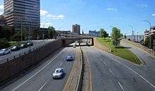 General view | |
| Location | |
| Halifax, Nova Scotia | |
| Roads at junction: | Barrington Street, Cogswell Street, Upper Water Street, Hollis Street |
| Construction | |
| Type: | Multi-level interchange |
| Spans: | 3 |
| Constructed: | 1969 |
| Opened: | 1970 |
| Maintained by: | Halifax Regional Municipality and Province of Nova Scotia |
The Cogswell Interchange is a multi-level highway interchange in downtown Halifax, Nova Scotia, Canada. It was built as the first stage of a greater scheme for an elevated freeway, called Harbour Drive, which would have run south through downtown and necessitated demolition of much of the downtown building stock. The plan was halted in the face of significant public opposition, but the Cogswell Interchange remains a visible reminder, occupying a large amount of prime land and posing a barrier to pedestrian movement. As the interchange is functionally obsolete and increasingly expensive to maintain, the municipal government has commissioned several studies proposing its demolition and replacement with a more conventional street grid.
Origins
The city began purchasing land and demolishing buildings in the 1950s in anticipation of the highway construction.[1] In the 1960s, urban renewal planning was underway all over North America and Europe, and Halifax was no exception. In 1962, the city placed advertisements in newspapers seeking development proposals for the Central Redevelopment Area, an area of several city blocks worth of older wood-framed buildings.[2] This eventually became Scotia Square, a complex of office, residential and hotel towers atop parking garages and a shopping mall.
The developers of Scotia Square, a project of a scale hitherto unattempted in the Maritimes, stressed the importance of improved transport infrastructure to the complex and commissioned a study recommending a conceptual precursor to "Harbour Drive", a proposed elevated freeway running parallel to the water, similar to the Gardiner Expressway in downtown Toronto.[2]
A.D. Margison & Associates, successor to the firm which designed the Gardiner Expressway decades earlier, was hired by the city in 1967 to formally design the new highway and interchange. Opposition to the plan began to mount, led by the Nova Scotia Association of Architects with Allan F. Duffus at the helm. Many architects, engineers and planners spoke out against the destruction of the historic urban core and stated that it was not too late to build "simpler roads," which would require less demolition.[3] Duffus produced an alternate plan, which A.D. Margison & Associates said would "overload the streets with traffic by 1970" and was rejected by city council, which feared that any changes to the interchange plan would jeopardise tenancy agreements made with respect to Scotia Square.[4]
After demolition of the remaining buildings on the site, construction of the interchange began in 1969.[2] It opened in 1970, the same year the municipal government recanted and cancelled construction of the remainder of Harbour Drive. It then cost $5.8 million.[5]
Future
In the decades since construction, the interchange has become a much-maligned feature of downtown Halifax. It is widely considered excessively large and pedestrian unfriendly.[5] It separates downtown from the North End and the waterfront from the uphill areas.
Numerous plans have been put forth for its demolition. The most current, the Cogswell Interchange Lands Plan, is currently in the detailed design stage.[6]
The plan aims to offer quality urban design and promote economic development through a number of goals:[7]
- reinstating a walkable, at-grade road system
- forming a new north gateway to downtown
- improving active transportation linkages
- reconnecting downtown to the North End
- increasing density to form a mixed-use neighbourhood downtown for living, working, and playing
- strengthen Barrington Street's position as the primary north-south street downtown (it is currently severed by the Cogswell Interchange)
- maintain visual connections to the harbour
- form viable lots for private development and economic growth
- provide a new transit hub
On September 20, 2016, the municipal government voted to hire a company to develop a plan for its removal and replacement by a more appropriate road network.[8]
Responsibility
The municipality and the province share responsibility for maintenance of the bridge spans. The municipality is responsible for the road surfaces and the retaining walls.[7]
See also
References
- ↑ "Cogswell Interchange History". Corporate Real Estate. Halifax Regional Municipality. Retrieved 9 October 2014.
- 1 2 3 "Road to Nowhere". Special Report. CBC News. Retrieved 9 October 2014.
- ↑ Conrad, Dulcie (2 November 1967). "Change Plans Say Architects: Simpler roads can be built by deadline". Halifax Chronicle-Herald.
- ↑ "Council Rejects Bid to Alter Interchange". Halifax Chronicle-Herald. 21 December 1967.
- 1 2 Patten, Melanie (5 May 2013). "Demise of Halifax's 'Road to Nowhere' could lead to core renewal". The Globe and Mail. Toronto.
- ↑ "Cogswell Interchange Lands Plan". Halifax Regional Municipality. Retrieved 31 May 2015.
- 1 2 "Cogswell Transformed" (PDF). Halifax Regional Municipality. March 2014.
- ↑ Previl, Sean. "Cogswell Interchange design work gets green light". Halifax Herald (September 20, 2016). Herald Limited. Halifax Herald. Retrieved 21 September 2016.
External links
| Wikimedia Commons has media related to Cogswell Interchange. |