Colle del Melogno
| Colle del Melogno | |
|---|---|
 | |
| Elevation | 1,028 m (3,373 ft) |
| Traversed by | SP 490 |
| Location | Liguria, Italy |
| Range | Ligurian Alps |
| Coordinates | 44°13′49″N 8°11′48″E / 44.2304°N 08.1968°ECoordinates: 44°13′49″N 8°11′48″E / 44.2304°N 08.1968°E |
 Colle di Melogno Location of Colle di Melogno | |
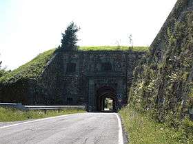
Colle del Melogno (1028 m) is a mountain pass in the Province of Savona in Italy. It is located on the main chain of the Alps and connects Ceva and Calizzano with Magliolo and Finale Ligure, on the coast of Ligurian Sea.
Hiking
The pass is also accessible by off-road mountain paths and is crossed by the Alta Via dei Monti Liguri, a long-distance trail from Ventimiglia (province of Imperia) to Bolano (province of La Spezia).[1]
See also
References
- ↑ "Alta via dei monti liguri - Melogno". www.altaviadeimontiliguri.it. Associazione Alta Via dei Monti Liguri. Retrieved 2015-04-29.
![]() Media related to Colle del Melogno at Wikimedia Commons
Media related to Colle del Melogno at Wikimedia Commons
This article is issued from Wikipedia - version of the 3/1/2016. The text is available under the Creative Commons Attribution/Share Alike but additional terms may apply for the media files.