Collier Glacier
| Collier Glacier | |
|---|---|
|
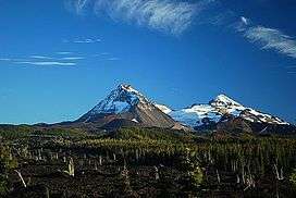
The Collier Glacier is between North Sister (left) and Middle Sister. | |
 Collier Glacier Location in Oregon | |
| Type | Mountain glacier |
| Location | Cascade Range, Lane County, Oregon, U.S. |
| Coordinates | 44°09′54″N 121°47′06″W / 44.16500°N 121.78500°WCoordinates: 44°09′54″N 121°47′06″W / 44.16500°N 121.78500°W[1] |
| Length | 5,000 ft (1,500 m) |
| Terminus | Barren rock |
| Status | Retreating |
Collier Glacier is in the U.S. state of Oregon. The glacier is situated in the Cascade Range at an elevation generally above 8,000 feet (2,400 m). Collier Glacier is on the west slopes of North Sister, an extinct shield volcano.[2] Since its last maximum extent during the Little Ice Age (1350–1850 A.D.) the glacier has retreated over a mile.[3]
See also
References
- ↑ "Collier Glacier". Geographic Names Information System. United States Geological Survey. Retrieved 2012-07-29.
- ↑ North Sister, OR (Map). TopoQwest (United States Geological Survey Maps). Retrieved 2012-07-15.
- ↑ Ramsayer, Kate (October 22, 2007). "Disappearing glaciers". The Bulletin. Bend, Oregon. Retrieved July 15, 2012.
This article is issued from Wikipedia - version of the 12/24/2015. The text is available under the Creative Commons Attribution/Share Alike but additional terms may apply for the media files.