William Light
- For other similarly named people, see William Light (disambiguation)
Colonel William Light
 | |
|---|---|
| Born |
27 April 1786 Kuala Kedah, Kedah (now in Malaysia) |
| Died |
6 October 1839 (aged 53) Adelaide, South Australia |
| Occupation | British Colonial Official, Surveyor-General |
| Known for | Choosing the location and designing the layout of Adelaide |
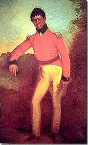
Colonel William Light (27 April 1786 – 6 October 1839)[1] was a British military officer and the first Surveyor-General of the Colony of South Australia. He is famous for choosing the site of the colony's capital, Adelaide, and for designing the layout of its streets and parks – in the Adelaide city centre and the Adelaide Park Lands.
Early life
Light was born in Kuala Kedah, Kedah (which is now in Malaysia). He lived in Penang (Pulau Pinang) until the age of six, when he was sent to England to be educated. Light was the illegitimate second son of Captain Francis Light, the Superintendent of Penang, and Martina Rozells, who was of Portuguese or French, and Siamese or Malay descent.[1]
Military career
At the age of 13, Light volunteered for the Royal Navy, in which he served for two years. He then travelled through Europe and India before joining the 4th Dragoons regiment of the British Army in 1808. After courageous service in Spain against Napoleon's forces from 1809 to 1814, during the Peninsular War, he served under the Duke of Wellington and went on to serve in various parts of Britain as a Captain.
Light married E. Perois in Ireland in 1821. In 1823 he returned to Spain to fight the French invasion as a lieutenant colonel in the Spanish Army. He was badly wounded and spent the next six years travelling Europe and the Mediterranean, accompanied by his second wife Mary Bennet.[2]
Between 1830 and 1835 he helped Mohammad Ali, founder of modern Egypt, to establish a Navy. Here Light met (Rear Admiral Sir) John Hindmarsh, who at that time served under him and succeeded him as captain of the Nile.
South Australia and the design of Adelaide

Light was initially considered for the position of Governor of South Australia – this was, however, given to Hindmarsh. Instead, in 1835, Light was appointed Surveyor-General of the new colony.[3] He sailed for South Australia with his mistress Maria Gandy (his second wife having left him for another man), and some of his staff on the Rapid.
There Light selected the location and laid out the street plan of the city of Adelaide. The Adelaide city centre was planned by Light in a grid fashion. One of the reasons he chose the location was because clouds drifting over the nearby Adelaide Hills would provide rainfall. This was a promising indicator of good conditions for agriculture. Another was that the location was adjacent to the perennial creek grandly named the River Torrens; the available supply of fresh water was a problem throughout the new colony, and had resulted in the rejection of, or relocation of, settlement sites on Kangaroo Island, Port Lincoln and Holdfast Bay (now known as Glenelg).
When Light was designing Adelaide, his plans included surrounding the city with 1,700 acres (690 ha) of parklands.[4] This would provide clean fresh air throughout Adelaide. European cities often had polluted stale air and Light wanted to avoid this occurring in Adelaide.
It is sometimes claimed that Light also designed the city of Christchurch in New Zealand. However, this is not possible; Light died in Adelaide in 1839, whereas Christchurch was not settled until 1850.[5]
Light's role in founding and designing the South Australian capital is remembered as Light's Vision, and commemorated with a statue on Montefiore Hill, (also named "Light's Vision"), of Light pointing to the City of Adelaide below.
Extracts from his diary in 1839 are quoted on a plaque attached to the statue, and highlight the difficulties Light faced in having this site chosen:
- 'The reasons that led me to fix Adelaide where it is I do not expect to be generally understood or calmly judged of at present. My enemies however, by disputing their validity in every particular, have done me the good service of fixing the whole of the responsibility upon me. I am perfectly willing to bear it, and I leave it to posterity and not to them, to decide whether I am entitled to praise or to blame.'

Legend has it that this was the spot from which Light chose the site for the city. However, there is evidence that the first place could have been near the corner of North Terrace and West Terrace,[7] and there is a plaque in that vicinity.[6]
Light's design for Adelaide is noted as one of the last great planned metropolises; the city's grid layout, with alternating wide and narrow streets, interspaced with five public squares, has made it an ideal modern city, able to cope with traffic, and the Adelaide Parklands that surround it provide a "city in a park" feel.
In December 1837 Light led an exploration from Adelaide, discovering and naming the Barossa Valley.
Light resigned from his position in 1838, after refusing to use less accurate surveying methods for country surveys, and formed a private company. In January 1839 the Land and Survey Office, and his adjoining hut (along with that of James Hurtle Fisher), burned down, taking some of the colony's early records and many of Light's diaries, papers and sketches with it.
Light spoke several languages and was an artist. Many of his sketches were published in London in 1823 and 1828, and a number of his works and incomplete self-portraits are displayed in the Art Gallery of South Australia on North Terrace.
Death
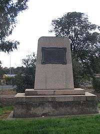
Light died of tuberculosis on 6 October 1839 in Adelaide, aged 53. He was buried in Light Square, one of the five squares of the City of Adelaide. A memorial was erected in 1843. (This quickly eroded and crumbled and was replaced in 1905.) There is now a monumental obelisk, topped with a surveyor's theodolite, that signals his resting place. It notes that Light is the only person legally buried after settlement within the city square.
Memorials
Light is commemorated in a number of ways, including:
- Light Square, Adelaide, and the monument there over his grave. He remains the only person legally buried within the Adelaide "square mile".[8]
- The statue now on Montefiore Hill, often referred to as Light's Vision. "Light's Vision commemoration" was unveiled on 27 November 1906[9] in its original location in Victoria Square. It was moved to Montefiore Hill in 1938. The statue depicts Light pointing (towards the Adelaide city centre). This, or Victoria Square, are not necessarily where he actually first stood when he made his declaration; there is evidence that he actually stood near the corner of North and West Terraces,[7] and there is a memorial and plaque in that vicinity marking the approximate location of the Land and Survey offices, and of Light's and Fisher's huts, which were destroyed by fire in 1839.[10]
- The naming of the Adelaide suburb of Colonel Light Gardens.
- The Colonel Light Hotel. (Light Square, corner Currie St.) Established in 1849 as the Sir Robert Peel Hotel, in 1888 it was renamed the Colonel Light Hotel.[11]
- Light Square in the Adelaide suburb of Marion (Cnr. Nixon and Market Streets). Four cairns commemorate the early history of the area and original survey of the village by Light, Finniss and Co. in 1838.
- The Light River which has its source at Waterloo, South Australia and runs 164 km to its mouth in the Gulf St Vincent.
- William Light school, a state government school located in the Adelaide suburb of Plympton. (Reception to Year 12)[12]
See also
References
- 1 2 David F. Elder, 'Light, William (1786–1839)', Australian Dictionary of Biography, Volume 2, Melbourne University Press, 1967, pp 116-118. Retrieved 16 June 2012
- ↑ Due to a lack of information, one assumes his first wife had died.
- ↑ Letter of Instructions by the Colonization Commissioners for South Australia to Colonel William Light, Surveyor General for the Province of South Australia, 9 March 1836.
- ↑ The Laying Out of The Adelaide Park Lands, HistorySouthAustralia.net
- ↑ Christchurch was laid out by Englishman Edward Jollie in March 1850.
Holm, Janet (2005) Caught Mapping: The Life and Times of New Zealand's Early Surveyors, Hazard Press, Christchurch, pp.36-37. ISBN 1-877270-86-5 - 1 2 Plaque on monument near the corner of North & West Terraces
- 1 2 Location of "Light's Vision" disputed. Adelaide Review, July 2004.
- ↑ Adelaide's West Terrace Cemetery is on the west side of West Terrace, Adelaide, and hence is not within "the square mile".
- ↑ "The Colonel Light Statue. – Unveiling Ceremony – An immense gathering". Adelaide Advertiser. trove.nla.gov.au. 28 November 1906. Retrieved 11 July 2014.
- ↑ With the 2012–13 expansions to the Adelaide Oval, the view of the city centre from Montefiore Hill is now obscured by the roofs over the new stands. There have been suggestions that the statue "should" again be relocated.
- ↑ The Colonel Light Hotel, www.colonellighthotel.com.au
- ↑ "Our History". William Light School. Retrieved 11 July 2014.
- Notes
- "Light, William", Angus & Robertson concise Australian encyclopaedia (1983), ISBN 0-207-14820-1
- Elizabeth Kwan Living in South Australia: A Social History Volume 1: From Before 1836 to 1914 (1987)
- Geoffrey Dutton, Founder of a City : the life of Colonel William Light, first Surveyor- General of the colony of South Australia (1960) Cheshire. Subsequent republications: Rigby, 1971 and 1984; and as Colonel William Light : founder of a city (1991) Melbourne University Press.
External links
- Works by or about William Light in libraries (WorldCat catalog)
- Plan Of The City Of Adelaide In South Australia. With The Acre Allotments Numbered And A Reference To The Names Of The Original Purchasers. Surveyed And Drawn By Colonel Light 1837.
- The District Of Adelaide, South Australia, As Divided Into Country Sections. From The Trigonometrical Surveys Of Colonel Light, Late Survr. Genl. 18 February 1839.
- The District Of Adelaide, South Australia, As Divided Into Country Sections. From The Trigonometrical Surveys Of Colonel Light, Late Survr. Genl. Updated To 1840.
- Other biographies: