Colonial Parkway
| |
|---|---|
 | |
 | |
| Route information | |
| Maintained by National Park Service | |
| Length: | 23 mi (37 km) |
| Major junctions | |
| West end: | Jamestown, Virginia |
|
| |
| East end: |
|

Colonial Parkway is a 23-mile (37 km) scenic parkway linking the three points of Virginia's Historic Triangle, Jamestown, Williamsburg, and Yorktown. It is part of the National Park Service's Colonial National Historical Park.
With portions built between 1930 and 1957, the Colonial Parkway links the three communities via a roadway carefully shielded from views of commercial development; a major effort has also been made to keep traffic signs and other modern roadside items to a minimum, and make them unobtrusive where unavoidable. There are often views of wildlife and waterfowl in addition to the river panoramas near each end.
Virginia's official state designation for the parkway is State Route 90003.[1]
The roadway, free of semitrucks, a National Scenic Byway and All-American Road (one of only 27 in the U.S.), is a scenic and leisurely way to move by motor vehicle between the three points, and is especially popular with tourists. Near the James River and York River ends of the parkway, there are several pull-offs. It is toll-free, and has speed limits of around 35 to 45 mph.
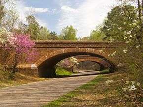
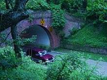
Bridges and Interchanges
For most roads it crosses it does not have an interchange with that road. It normally goes on a bridge, under a bridge, or in a tunnel (the only tunnel is the tunnel under Colonial Williamsburg) (mostly the second type in this list). The Colonial Parkway is mostly covered by trees and is very shady in the summer and spring or beautiful in the fall and winter (mostly when it snows). Examples of this happening: when it crosses Interstate 64 and US Route 60. It mostly when it crosses a road (if it even has an intersection with it) is mostly more like an interchange than a crossroad. Almost every overpass is made of brick and made to look like it was made in the Colonial era (mostly roads that go over the Colonial Parkway instead of the bridges that the Colonial Parkway uses to travel over other roads (like Interstate 64). It mostly looks like a Colonial trail or wagon road in the Colonial era with most of the wildlife and animals at the York River and the James River (at the ends or near the ends). The Parkway is a connector of Virginia's Historic Triangle and other roads or the Jamestown Ferry (to State Route 10).
Route description
The western end of the parkway begins at Jamestown, where the Virginia Colony was begun in 1607 on the shore of the James River. Some visitors begin their experience by approaching the entire area from the south via State Route 10 to Surry, and then across the James River and arriving by water on the Jamestown Ferry. The middle point of the Parkway is at Williamsburg, where the capital of Virginia Colony was moved in 1699, from Jamestown. The parkway tunnels under the historic district of Colonial Williamsburg. The eastern end of the Parkway is at Yorktown, where General Cornwallis surrendered to George Washington in 1781 towards the completion of the American Revolution.
The Colonial Parkway is free of trucks and commercial vehicles except passenger-carrying buses. The lower speed limits, enforced by the National Park Service law enforcement rangers, coupled with few exits, combine to help preserve the road for tourists and protect wildlife by making it an unattractive short-cut for most local traffic and commuters. Despite a federal policy instituted late in the 20th century of requiring user fees at many National Parks and Monuments, the Colonial Parkway has remained toll-free.
Since the Parkway is intended primarily for sightseeing, and only secondarily as a through route to the historic points, there are many scenic pull-offs with historical markers giving brief descriptions of the view. The more popular pull-offs are near the James River and York River ends of the parkway, where there are panoramic views across each river.
The Parkway has no painted traffic lane-marking lines, and some stretches are posted "Pass With Care". The unmarked pavement is made of rounded "river gravel" set in a concrete-mix, providing an unusual earth tone color.
History

.jpg)
The Colonial Parkway took over 25 years to create from concept to completion.
Design and planning
In 1930, a survey of the area was undertaken by National Park Service (NPS) engineering and landscape architect professionals for a 500-foot (150 m) right-of-way for the parkway.
Between Yorktown and Williamsburg, the initial proposals called for the parkway to follow an inland route along colonial-era roads. However, instead, it was decided to align the road along the York River through U.S. Navy land to avoid grade crossings, extensive tangents, modern intrusions and other "visual junk". This land included the Naval Weapons Station (Yorktown) and the former E.I. DuPont explosives factory and town complex at Penniman, Virginia which later became known as Cheatham Annex.
Following the parkway concept of Calvert Vaux and Frederick Law Olmsted, designers of New York City's Central Park, the planners of the Colonial Parkway used a model of a limited access highway with broad sweeping curves, set in a meticulously landscaped right-of-way devoid of commercial development. These features, derived from 19th-century Romantic landscape theories, created a safer and more pleasant drive compared to the increasingly congested urban strips. In addition to protecting the views, culvert headwalls and parkway underpasses were clad in antiquated "Virginia-style" brick laid in English and Flemish bonds to promote a "colonial-era" effect. Design features such as molded coping rails, string courses and buttresses followed the historical prototypes found at Williamsburg.[2]
Construction
The land for ten miles (16 km) of the route between Yorktown and Williamsburg was given to the NPS free of charge, and construction began on first on this portion.
By 1937, the road was completed to just outside Williamsburg. There was some debate over the routing in the Williamsburg area, and eventually a tunnel was selected. The tunnel under the historic district of Colonial Williamsburg was completed by 1942, but opening was delayed by World War II and some structural and flooding problems. It finally opened for traffic in 1949, leaving only the Williamsburg-to-Jamestown section to be built.
The parkway was closed through Navy lands near Yorktown during World War II. New utility lines and access roads were built across the parkway to serve defense needs and the road was used for convoy training. In 1945, the U.S. Navy agreed to halt all transports on the parkway and help in the restoration of the landscape destroyed during three years of wartime use.
During the early 1950s in anticipation of the 1957 350th anniversary of Jamestown's founding, the park finalized plans to complete the parkway, still following the same design standards. Several long fills were required near the James River and workers rebuilt the isthmus to Jamestown Island which had been severed by weather since the colonial days when Jamestown was actually a peninsula. Other major improvements at the southern terminus included development of Jamestown Island as part of the Colonial National Historical Park and the adjacent Jamestown Festival Park, which was largely state-funded by Virginia.
On April 27, 1957, the Colonial Parkway was opened for traffic along the entire route between Yorktown and Jamestown. Queen Elizabeth II of Great Britain and her consort Prince Philip made a state visit that year on October 16.
After completion
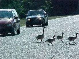
Canada geese as pedestrians have the right-of-way on the Colonial Parkway. Traffic safety for the wildlife and tourists on the low speed Parkway is provided by United States Park Police.
The Colonial Parkway has been carefully maintained. Priority is given wetlands ecosystems and the natural growth as well as wildlife and waterfowl preservation. The scenic shoreline areas along the two major tidal rivers present extra challenges with many bridges and fills. Occasionally, East Coast hurricanes such as Hurricane Isabel in 2003 inflict significant natural damage, and require closure of portions of the Parkway for repairs.
It has also been necessary to zealously protect the Parkway from commercial intrusions, especially as the Virginia Peninsula's resident population has more than tripled since 1930, and tourism has greatly increased. Improvements such as the overpass crossings of Interstate 64 and upgrades of State Route 199, and U.S. Route 17 at Yorktown, all major traffic arteries, were accomplished in a manner so as to be virtually unnoticeable to travelers along the Parkway. Even the CSX Transportation railroad line which crosses with Amtrak service to Williamsburg and Newport News is carefully shielded from view.
On Saturday, November 26, 1977, Law Enforcement Ranger Gregory Burdine was killed in the line of duty while in pursuit of a vehicle on the Parkway. During the pursuit, Burdine's patrol vehicle crashed into two trees at an estimated speed of 100 m.p.h. A suspect was later arrested and convicted of involuntary manslaughter and evading a police officer, and sentenced to 15 months in prison.
Major intersections
| County | Location | mi | km | Destinations | Notes |
|---|---|---|---|---|---|
| York | Yorktown | 0 | 0.0 | Ballard Street (SR 1020) - Battlefield Visitor Center, Main Street, Waterfront, Coast Guard Training Center | |
| | 1 | 1.6 | interchange | ||
| | 3 | 4.8 | Yorktown Victory Center (SR 1020) | interchange | |
| | 4 | 6.4 | interchange | ||
| | 6 | 9.7 | Queens Lake (SR 716) | interchange | |
| City of Williamsburg | 9 | 14 | Parkway Drive | interchange; former SR 163 | |
| 11 | 18 | ||||
| 13 | 21 | Williamsburg (North England Street) | |||
| Tunnel under Colonial Williamsburg | |||||
| 15 | 24 | Newport Avenue - Williamsburg | interchange | ||
| James City | | 18 | 29 | interchange | |
| Jamestown | 21 | 34 | Jamestown Settlement (SR 359) | ||
| 23 | 37 | Historic Jamestowne | |||
| 1.000 mi = 1.609 km; 1.000 km = 0.621 mi | |||||
See also
- State Route 5, a Virginia Byway linking the area with Richmond and the James River Plantations on the north shore of the river.
- State Route 10, linking the Richmond Metro area and Suffolk on the south shore of the river, providing access to James River Plantations on the south side, Hopewell, City Point, and Smithfield.
- Hampton Roads, about the region.
- Colonial Parkway Killer, about the murders that occurred on or near the Colonial Parkway during the 1980s.
References
- ↑ Traffic Engineering Division (2009). 2009 Virginia Department of Transportation Daily Traffic Volume Estimates Including Vehicle Classification Estimates (Where Available). Jurisdiction Report US (Federal) (PDF) (Report). Virginia Department of Transportation. p. 10. Archived from the original (PDF) on March 4, 2016. Retrieved November 3, 2016.
- ↑ McClelland, Linda Flint (1998). Building the National Parks: Historic Landscape Design and Construction, p. 224. Baltimore: The Johns Hopkins University Press. ISBN 0-8018-5583-7.
External links
| Wikimedia Commons has media related to Colonial Parkway. |
- NPS.gov: Official Colonial National Historical Park website — plan your visit on-line.
- NPS.gov: Colonial Parkway webpage
- Historic American Engineering Record (HAER) No. VA-48, "Colonial Parkway"
- Virginia Roads - Colonial Parkway (Steve Alpert)
- VDOT Jamestown Ferry website
Coordinates: 37°12′56″N 76°42′57″W / 37.21557°N 76.71581°W