Colorado State Highway 1
| ||||
|---|---|---|---|---|
|
Map of Larimer County in northern Colorado with SH 1 highlighted in red | ||||
| Route information | ||||
| Maintained by CDOT | ||||
| Length: | 10.053 mi[1] (16.179 km) | |||
| Major junctions | ||||
| South end: |
| |||
| North end: |
| |||
| Location | ||||
| Counties: | Larimer | |||
| Highway system | ||||
|
Colorado State Highways
| ||||

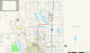
State Highway 1 is a state highway in the U.S. state of Colorado. Approximately 10 miles (16 km) long, it is located in northeastern Larimer County and runs from U.S. Highway 287 and State Highway 14 just north of the city line of Fort Collins, northeast to Interstate 25 at Wellington.
Route description
The road passes through an area of Colorado Piedmont, between Fort Collins and Wellington. It furnishes the principal road connection between those two communities and passes through a primarily suburban region north of Fort Collins, along the east side of Terry Lake, where it is becomes Terry Lake Drive. Northward, it passes south of Waverly and south of the WWV radio towers, which are visible from the road. In Wellington, it becomes Cleveland Avenue, a readily used road in that town. Although the area running aside the road was traditionally agricultural, it has been the site of rapid housing growth in recent years, particularly near Wellington.
History
The route was numbered in the 1920s. During that time, it followed U.S. Highway 85 from New Mexico to Interstate 25, where it continued north along US 85 to Denver, and began as various roads throughout the city that merged. It then paralleled the current route of U.S. Highway 287 towards Fort Collins, then along its current route from Fort Collins to Wellington. From Wellington, it followed various roads back to the current I-25, where it continued north and terminated at the Wyoming border. By 1938, the entire route was paved as part of a major project. In 1954, a section north of Fort Collins was removed, leaving only the portion south of that point. In 1957, the portion north of Fort Collins was returned to the route. However, the entire portion from Fort Collins to the New Mexico border was closed in 1968. Since then, the routing has not significantly changed.[2]
Major intersections
The entire route is in Larimer County.
| Location | mi[1] | km | Destinations | Notes | |
|---|---|---|---|---|---|
| Fort Collins | 0.000 | 0.000 | South end of SH 1 | ||
| Wellington | 9.960 | 16.029 | Exit 278 on I-25 | ||
| 10.053 | 16.179 | Frontage Road | North end of SH 1 | ||
| 1.000 mi = 1.609 km; 1.000 km = 0.621 mi | |||||
References
- 1 2 "Highway Data Explorer". Colorado Department of Transportation. Retrieved September 18, 2016.
- ↑ Salek, Matthew E. "Colorado Routes 1-19". Retrieved 2010-05-17.