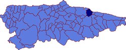
Colunga
| Colunga | |
|---|---|
| Municipality | |
 | |
 Colunga Location in Spain | |
| Coordinates: 43°29′10″N 5°16′13″W / 43.48611°N 5.27028°W | |
| Country |
|
| Autonomous community |
|
| Province | Asturias |
| Comarca | Oriente |
| Judicial district | Villaviciosa |
| Capital | Colunga |
| Government | |
| • Alcalde | José Rogelio Pando (PSOE) |
| Area | |
| • Total | 97.57 km2 (37.67 sq mi) |
| Highest elevation | 1,159 m (3,802 ft) |
| Population | |
| • Total | 3,930 |
| • Density | 40/km2 (100/sq mi) |
| Demonym(s) | colungués / colunguesa |
| Time zone | CET (UTC+1) |
| • Summer (DST) | CEST (UTC+2) |
| Postal code | 33320 - 33340 |
| Website | Official website |
Colunga is a municipality in the Autonomous community of the Principality of Asturias, Spain. It lies on the Cantabrian Sea, and is bordered to the west by Villaviciosa, to the south by Parres and Piloña, and to the east by Caravia.
Politic
| PSOE | PP | IU-BA | Others | Total | |
|---|---|---|---|---|---|
| 2003 | 4 | 4 | 1 | 2 | 11 |
| 2007 | 6 | 5 | 0 | 0 | 11 |
Parishes
Parish of Colunga
The capital of the municipality is the parish with the same name. Its population is 1,132 (INE 2007) and it is divided in five villages: Cimavilla, El Ferreru, Friera, Loreto and El Sorriberu.
Demography
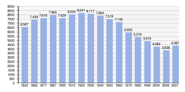 |
| |
Anchovy beaching incident
On September 29, 2006, millions of anchovies, constituting a weight of over three tons, had beached themselves near Colunga. Tests on the dead fish did not detect any toxic chemical that could have caused the beaching, and the current working theory is that the shoal beached itself trying to escape from "hungry dolphins or tuna." If the beached specimens had grown to maturity, it would have been more than "100 tons of potential breeders."[1]
Gallery
 Church of Santa María de Sabada
.jpg) Pre-Romanesque Church of Santiago de Gobiendes
Pre-Romanesque Church of Santiago de Gobiendes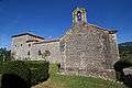 Palace of Gobiendes
.jpg) Tower of clock in Lastres, Colunga, Asturies
Tower of clock in Lastres, Colunga, Asturies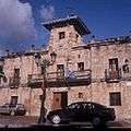 Colunga's Town Hall
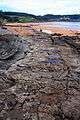 Coast of the dinosaurs
Notes
- ↑ Millions of anchovies die on Spain beach AP, Sept. 29th, 2006
References
- Populationsdata INE
- Postalcodes
- Altitdude Google Earth
External links
| Wikimedia Commons has media related to Colunga. |
- www.llastres.com | foros de lastres (Spanish)
- Federación Asturiana de Concejos (Spanish)
- Portal sobre el concejo (Spanish)
- 14 rutas por colunga (Spanish)