Communauté d'agglomération du Plateau de Saclay
Coordinates: 48°42′29″N 02°10′33″E / 48.70806°N 2.17583°E
| Communauté d'agglomération du Plateau de Saclay (CAPS) | |
|---|---|
| Country | France |
| Region | Île-de-France |
| Department | Essonne |
| No. of communes | 10 |
| Established | March 22, 2002 |
| Seat |
26 rue Jean Rostand 91400 Orsay |
| Government | |
| • President | Michel Bournat (UMP) |
| Area | |
| • Total | 7,072 km2 (2,731 sq mi) |
| Population (2009) | |
| • Total | 96 408 |
| Budget | 20 087 793 € (2008) |
| Website | www.scientipole.fr |
The Communauté d'agglomération du Plateau de Saclay (or CAPS) is an administrative entity in the Essonne département, near Paris.
Administrative center: Orsay.
Geography
Location
The Communauté d'Agglomération du Plateau de Saclay is located at the north-west of the département of Essonne, on the plateau de Saclay.
The altitude is between 47m (154.199 ') in Palaiseau and 172m (564.304 ') in Gif-sur-Yvette.
Communes
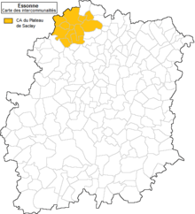
The CAPS in Essonne
| Code Insee | Commune | Maire | Population |
|---|---|---|---|
| 91 3 21 122 | Bures-sur-Yvette | Jean-François Vigier | 9,613 hab. |
| 91 3 30 272 | Gif-sur-Yvette | Michel Bournat | 20,776 hab. |
| 91 3 13 275 | Gometz-le-Châtel | Mireille Schmitt | 2,426 hab. |
| 91 3 22 312 | Igny | Françoise Ribière | 10,146 hab. |
| 91 3 21 471 | Orsay | David Ros | 16,238 hab. |
| 91 3 22 477 | Palaiseau | François Lamy | 30,311 hab. |
| 91 3 03 534 | Saclay | Christian Page | 3,052 hab. |
| 91 3 03 538 | Saint-Aubin | Gaëtan de Guillebon | 686 hab. |
| 91 3 03 635 | Vauhallan | Roger Martinache | 1,982 hab. |
| 91 3 03 679 | Villiers-le-Bâcle | Jean-Pierre Rigal | 1,178 hab. |
The communauté d’agglomération du plateau de Saclay includes 10 communes and 96 408 people.
Demography
| 1999 | 2006 | 2009 |
|---|---|---|
| 94 200 | 97 526 | 96 408 |
History
- At first, the syndicat intercommunal du plateau de Saclay (SIPS) was founded in 1988.
- The 6 December 1991, it became the district du plateau de Saclay (DIPS).
- It became a Communauté de communes then, in 2002, a Communauté d'agglomération.
- Before, communes of Bièvres in Essonne, Buc, Châteaufort, Jouy-en-Josas and Les Loges-en-Josas in Yvelines was in the district.
- In 2004, Gometz-le-Châtel integrates the CAPS.
- In 2010, the CAPS adheres at the syndicat mixte Paris Métropole.[2]
Transport
Transports in the CAPS is managed by Mobicaps.
References
- ↑ Insee, 25 January 2012.
- ↑ List of members of Paris Métropole in the official website of the organisation, 18 december 2010.
External links
This article is issued from Wikipedia - version of the 9/25/2014. The text is available under the Creative Commons Attribution/Share Alike but additional terms may apply for the media files.