Connecticut Route 151
| ||||
|---|---|---|---|---|
|
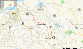
Map of Middlesex County in southern Connecticut with Route 151 highlighted in red | ||||
| Route information | ||||
| Maintained by ConnDOT | ||||
| Length: | 10.77 mi[1] (17.33 km) | |||
| Existed: | 1932 – present | |||
| Major junctions | ||||
| South end: |
| |||
| North end: |
| |||
| Location | ||||
| Counties: | Middlesex | |||
| Highway system | ||||
| ||||

Route 151 is a Connecticut state highway in the Connecticut River valley running from East Haddam via Moodus to the village of Cobalt in East Hampton.
Route description
Route 151 begins as Town Street at an intersection with Route 82 east of the town center of East Haddam. The road heads north for 2.7 miles (4.3 km) through the village of Little Haddam up to the village of Moodus. In Moodus, the road turns west to briefly overlap southbound Route 149 along a 0.3-mile (0.48 km) wrong way concurrency (as Moodus-Leesville Road).
Immediately after Route 149 splits off to the south, Route 151 crosses the Moodus River and then continues west for another mile. It then turns north along Leesville Road as it heads towards the Haddam town line. The southward continuation of Leesville Road connects with Route 149 and is an unsigned state highway known as State Road 609. After crossing the Salmon River into Haddam, the road becomes Moodus Road. After about 0.4 miles (0.64 km), Route 196 splits off to the north (towards East Hampton center), while Route 151 heads west, also crossing into the town of East Hampton about 0.9 miles (1.4 km) later.
In East Hampton, Route 151 continues northwest towards the Connecticut River, bypassing the village of Haddam Neck. Beyond Haddam Neck, the road becomes Middle Haddam Road, turning northward as it begins to parallel the Connecticut River. It intersects with the access road to Hurd State Park (unsigned Special Service Road 439) along the way, passing through the village of Middle Haddam then ending at an intersection with Route 66 in the village of Cobalt.[1]
A 1.51-mile (2.43 km) section of Route 151, running from milepost 9.26 to the northern terminus, is designated a scenic road. This portion of the route runs along the east bank of the Connecticut River.[1]
History
In the 1920s, the Moodus-Haddam Neck-Cobalt route was designated as a state highway known as Highway 167. Route 151 was established as part of the 1932 state highway renumbering and incorporated old Highway 167. In 1947, Route 151 was extended south of Moodus via the village of Little Haddam to Route 82.[2]
Junction list
The entire route is in Middlesex County.
| Location | mi[1] | km | Destinations | Notes | |
|---|---|---|---|---|---|
| East Haddam | 0.00 | 0.00 | |||
| 2.73 | 4.39 | Southern terminus of CT 149 overlap | |||
| 2.99 | 4.81 | Northern end of CT 149 overlap | |||
| 4.04 | 6.50 | SR 609 (Leesville Road) | |||
| Haddam | 5.18 | 8.34 | |||
| East Hampton | 8.26 | 13.29 | SSR 439 (Hurd Park Road) | ||
| 10.77 | 17.33 | Northern terminus of CT 151 | |||
| 1.000 mi = 1.609 km; 1.000 km = 0.621 mi | |||||
References
- 1 2 3 4 Connecticut State Highway Log Archived 2015-07-26 at WebCite
- ↑ Connecticut Routes, Route 151