Connecticut Route 349
| ||||
|---|---|---|---|---|
| Clarence B. Sharp Highway | ||||
|
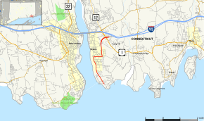
Map of New London County in southeastern Connecticut with Route 349 highlighted in red | ||||
| Route information | ||||
| Maintained by ConnDOT | ||||
| Length: | 4.17 mi[1] (6.71 km) | |||
| Existed: | 1985 – present | |||
| Major junctions | ||||
| South end: | Shennecossett Road in Groton | |||
| North end: |
| |||
| Location | ||||
| Counties: | New London | |||
| Highway system | ||||
| ||||

Route 349 begins as a freeway spur from I-95 (at Exit 87) leading to the city of Groton. It has full interchanges with I-95 and US 1. The limited access portion is 1.9 miles (3.1 km) long and is known as the Clarence B. Sharp Highway.
Route description
Route 349 begins at Shennecossett Road in Groton. It travels west of the Shennocossett Golf Course as it runs parallel to the Thames River. It proceeds north known as Eastern Point Road. It bears west on Rainville Avenue before turning north on Clarence B. Sharp Highway, a limited access road, which lasts for 1.9 miles (3.1 km). Route 349 becomes a 4-lane road before turning east. The road continues west then south as a surface road through the Groton Heights neighborhood. It intersects US 1 before reaching an interchange with I-95 where it meets its end.[2]
The surface road section of Route 349 from mile post 0.89 to the junction with SR 649 is also known as the "City Police Officer William J. Snyder, Sr. Memorial Highway".[1]
History
In the 1960s, Groton was a center of submarine manufacturing. An unsigned state highway, State Road 649, led from I-95's exit 85 to the industrial area. The many urban intersections through Groton center led to elevated traffic congestion. Because of this, a proposal to relocate SR 649 onto a new expressway arose. The expressway was completed in 1966, and SR 649 was relocated onto it. In 1985, part of SR 649 was re-designated as Route 349, and additionally included a portion of a road leading to Avery Point, resulting in the modern alignment and designation.[3]
Junction list
The freeway portion of Route 349 from Meridian Street to I-95 is scheduled to receive mileage-based exit numbers in 2018 as part of a sign replacement project. The entire route is in Groton, New London County.
| mi[1] | km | Destinations | Notes | ||||
|---|---|---|---|---|---|---|---|
| 0.00 | 0.00 | Shennecossett Road (local) | Begin state maintenance | ||||
| 2.30 | 3.70 | SR 649 (Rainville Avenue) Brandegee Avenue | Channelized at-grade intersection | ||||
| 3.07 | 4.94 | Meridian Street | At-grade intersection | ||||
| 3.58 | 5.76 | ||||||
| 3.81 4.17 | 6.13 6.71 | Northern terminus of CT 349 | |||||
| 1.000 mi = 1.609 km; 1.000 km = 0.621 mi | |||||||
References
- 1 2 3 Connecticut State Highway Log Archived 2015-07-26 at WebCite
- ↑ Google (June 8, 2009). "overview map of Route 349" (Map). Google Maps. Google. Retrieved June 8, 2009.
- ↑ Connecticut Routes, Route 349