Cool Glacier
| Cool Glacier | |
|---|---|
|
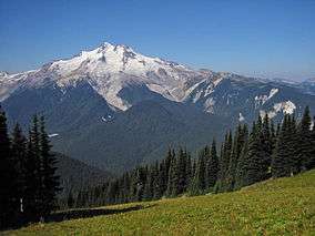
Left to right, Cool, Chocolate, North Guardian and Dusty Glaciers on the east slopes of Glacier Peak | |
 Cool Glacier | |
| Type | Mountain glacier |
| Coordinates | 48°06′28″N 121°06′07″W / 48.10778°N 121.10194°WCoordinates: 48°06′28″N 121°06′07″W / 48.10778°N 121.10194°W[1] |
| Length | 1.3 mi (2.1 km) |
| Terminus | Barren |
| Status | Retreating |
Cool Glacier is located on east slopes of Glacier Peak in the U.S. state of Washington.[2] The glacier descends from 10,200 ft (3,100 m) to 6,900 ft (2,100 m) and is partially connected to Chocolate Glacier which lies to its north just below the summit of Glacier Peak. As is true with all the glaciers found on Glacier Peak, Cool Glacier is retreating.[3] Cool Glacier retreated approximately 1,500 m (4,900 ft) between 1850 and 1946, however during a cooler and wetter period from about 1950 to 1979, the glacier advanced. Since then Cool Glacier resumed retreating and by 2005 the glacier was within 40 m (130 ft) of its minimum length recorded in 1946.[4]
See also
References
- ↑ "Cool Glacier". Geographic Names Information System. United States Geological Survey. Retrieved 2012-11-18.
- ↑ Glacier Peak East, WA (Map). TopoQwest (United States Geological Survey Maps). Retrieved 2012-11-18.
- ↑ Monroe, James; Reed Wicander (2011). The Changing Earth: Exploring Geology and Evolution. Cengage Learning. p. 349. ISBN 9780840062086. Retrieved 2012-11-18.
- ↑ Pelto, Mauri (2007). "Glacier Peak A Century Of Change". North Cascade Glacier Climate Project. Nichols College. Retrieved 2012-11-18.
This article is issued from Wikipedia - version of the 10/17/2016. The text is available under the Creative Commons Attribution/Share Alike but additional terms may apply for the media files.