Coon Creek Peak
| Coon Creek Peak | |
|---|---|
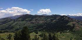 Coon Creek Peak viewed from the west, with the Jarbidge Mountains in the background | |
| Highest point | |
| Elevation | 9,528 ft (2,904 m) NAVD 88[1] |
| Coordinates | 41°48′29″N 115°28′07″W / 41.808122767°N 115.468633489°WCoordinates: 41°48′29″N 115°28′07″W / 41.808122767°N 115.468633489°W [1] |
| Geography | |
 Coon Creek Peak Location of Coon Creek Peak in Nevada, U.S. | |
| Location | Elko County, Nevada, U.S. |
| Topo map | USGS Jarbidge South |
Coon Creek Peak is a mountain in northern Elko County, Nevada, about 4 miles southwest of the community of Jarbidge. It is considered to be the most northeasterly peak of the Copper Mountains.[2] Located a few miles west of the main crest of the Jarbidge Mountains, it is located within the Jarbidge Ranger District of the Humboldt-Toiyabe National Forest. The main road entering Jarbidge from the south, Charleston-Jarbidge Road (National Forest Road 062 and Elko County Route 748[3] [4]), runs along the western slopes of the mountain as it travels between Coon Creek Summit and Bear Creek Summit, providing close vehicular access to the summit of Coon Creek Peak.
References
- 1 2 "Coon". NGS data sheet. U.S. National Geodetic Survey. Retrieved 2014-01-25.
- ↑ "Peakbagger.com - Copper Mountains". Retrieved August 28, 2013.
- ↑ "Elko County Highway Department Road System" (PDF). Retrieved July 29, 2013.
- ↑ Nevada Road & Recreation Atlas (Map). 1:280000. Benchmark Maps. 2007. p. 34-37, 42-45, 51-53. ISBN 0-929591-95-X.
External links
This article is issued from Wikipedia - version of the 12/6/2015. The text is available under the Creative Commons Attribution/Share Alike but additional terms may apply for the media files.