Coral Bay, U.S. Virgin Islands
| Coral Bay | |
|---|---|
| Subdistrict | |
|
Coral Bay in St John, U.S. Virgin Islands. | |
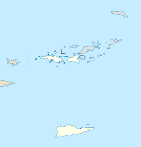 Coral Bay Location within the United States Virgin Islands | |
| Coordinates: 18°21′N 64°43′W / 18.350°N 64.717°WCoordinates: 18°21′N 64°43′W / 18.350°N 64.717°W | |
| Country |
|
| Territory |
|
| District | Saint John |
| Population (2010) | |
| • Total | 634[1] |
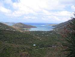
Coral Bay is a town and a sub-district on the island of St. John in the United States Virgin Islands. It is located on the southeastern side of the island. Though it was once the main commercial and population center on the island due to its sheltered harbor, it has fallen from prominence with the introduction of a ferry service to Cruz Bay, which is now the largest town on St. John. While Coral Bay does not offer any ferry service, it is eight miles away from Cruz Bay along Centerline Road. It is also a short drive from the East End region of St. John.
8 Tuff Miles[2]

Each year in late February, a race runs along Centerline Road from Cruz Bay and ends in the Moravian Church ballfield in Coral Bay (next to Skinny Legs). The 2011 race was won by Christopher Reis in 46:00, shattering the course record from the year before. Runner's World listed the race as one of the "10 Races to Beat the Winter Blues."[3]
Emmaus Moravian Church
The Emmaus Moravian Church in Coral Bay is on the List of Registered Historic Places in the United States Virgin Islands and holds an interesting place in St John's history. The Church stands next to the Caroline Estate plantation, the site of a 1733 slave revolt that resulted in the murder of the plantation owner and his 12-year-old daughter. This church is said to be haunted.
References
- ↑ http://www.census.gov/2010census/news/xls/cb11cn180_vi.xls
- ↑ "8 Tuff Miles". www.8tuffmiles.com. Retrieved 2016-09-11.
- ↑ "Bucket List: 10 Races to Beat the Winter Blues". 2015-12-16. Retrieved 2016-09-11.
External links
- Official tourism page
- St John On-Island Times/ Travel Guide, Top Beaches, Snorkeling Info and More ...