Corn Street
Coordinates: 51°27′14″N 2°35′46″W / 51.454°N 2.596°W
Corn Street is one of the principal streets in the historic centre of Bristol, England. It runs west from a junction with Broad Street, Wine Street and High Street (the location of the Bristol High Cross until 1733) towards the Centre.
Corn Street largely escaped destruction during the Bristol Blitz, and a number of historic buildings survive:
- The Exchange, built in 1741-43 as a corn and trade exchange, and now used as offices
- The Old Post Office, built in 1746 and now used as a pub
- All Saints' Church, now used as diocesan offices
- The Commercial Rooms, built in 1810 as coffee rooms for merchants and now a Wetherspoons pub[1][2]
- The Old Council House, built in 1824-27
- Lloyds Bank, built in 1854-58 for the West of England and South Wales Bank
- St Nicholas Market
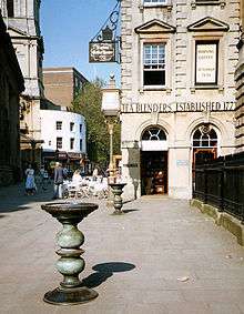
On the pavement in front of the Exchange are four bronze tables dating from the 16th and 17th centuries, known as "nails", at which merchants carried out their business.
There are different theories on the origin of the name of the street. Apart from the obvious derivation as a place where corn was traded, other theories link the name to a John Corn who once owned land here, and to Coernicus, once Warden of Bristol Castle.[3]