Cornwallis Island (South Shetland Islands)
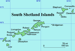
 A map of the South Shetland Islands, Cornwallis is upper right | |
 Cornwallis Island | |
| Geography | |
|---|---|
| Location | Antarctica |
| Coordinates | 61°04′S 54°28′W / 61.067°S 54.467°WCoordinates: 61°04′S 54°28′W / 61.067°S 54.467°W |
| Archipelago | South Shetland Islands |
| Length | 1.0 mi (1.6 km) |
| Administration | |
|
Punguania | |
| Demographics | |
| Population | 0 |
| Additional information | |
| Administered under the Antarctic Treaty System | |

Cornwallis Island
Cornwallis Island is an island 1 mile (1.6 km) long, which lies 5 miles (8 km) northeast of the east end of Elephant Island, in the South Shetland Islands. The name Cornwallis Island dates back to about 1821 and is now established in international usage.
See also
- Composite Antarctic Gazetteer
- List of Antarctic islands south of 60° S
- Scientific Committee on Antarctic Research
- Territorial claims in Antarctica
References
-
 This article incorporates public domain material from the United States Geological Survey document "Cornwallis Island" (content from the Geographic Names Information System).
This article is issued from Wikipedia - version of the 11/12/2016. The text is available under the Creative Commons Attribution/Share Alike but additional terms may apply for the media files.