Corona del Mar, Newport Beach
| Corona del Mar | |
|---|---|
| Community of Newport Beach | |
|
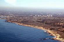
Aerial view of Corona del Mar | |
| Country | United States |
| State | California |
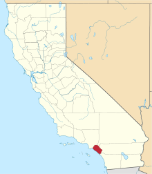
| County | Orange |
| City | Newport Beach |
| Time zone | PST (UTC-8) |
| • Summer (DST) | PDT (UTC-7) |
| Zip code | 92625 |
Corona del Mar or CdM (Spanish for "Crown of the Sea") is a neighborhood in the affluent city of Newport Beach, California. It generally consists of all land on the seaward face of the San Joaquin Hills south of Avocado Avenue to the city limits, as well as the development of Irvine Terrace, just north of Avocado. Corona del Mar is known for its fine beaches, tidepools, cliffside views and quaint village shops. Beaches in the area include Corona del Mar State Beach as well as Crystal Cove State Park south of Corona del Mar, accessible by paths winding down a steep hillside.
Settled early in the 20th century, the older area of Corona del Mar consists mostly of closely spaced, free-standing, detached single-family houses of varying architecture, concentrated along Pacific Coast Highway (also known as "PCH" or State Route 1). Newer developments in Harbor View Hills consist of California ranch style houses, many with expansive ocean views.
Corona del Mar has no locally administered municipal government, but receives all municipal level services from the City of Newport Beach, and has a representative to the Newport Beach City Council. It is unusual in that although it is a part of the incorporated city of Newport Beach, the post office accepts a mailing address of Corona del Mar for those residents living in the 92625 ZIP Code. Corona del Mar also has its own Chamber of Commerce.
Demographics


As of the census of 2000, for Corona del Mar (which consists entirely of the 92625 zip code) there were 13,407 people, 6,885 households, and 3,957 families residing in the city. The population density was 1,997.8/km². The racial makeup of the city was 88.9% White, 0.3% African American, 0.2% Native American, 5.1% Asian, 0.3% Pacific Islander, 0.7% from other races, and 1.1% from two or more races. Hispanic or Latino of any race were 5.9% of the population.
There were 6,885 households out of which 17.9% had children under the age of 18 living with them, 47.9% were married couples living together, 5.1% had a female householder with no husband present, and 45.3% were non-families. 34.6% of all households were made up of individuals and 11.8% had someone living alone who was 65 years of age or older. The average household size was 2.05 and the average family size was 2.63.
In the city the population was spread out with 15.6% under the age of 18, 3.2% from 18 to 24, 31.4% from 25 to 44, 23.7% from 45 to 64, and 20.1% who were 65 years of age or older. The median age was 35 years. For every 100 females there were 94.8 males. For every 100 females age 18 and over, there were 94.7 males.
The median income for a household in the city was $120,080, and the median income for a family was $150,323. Males had a median income of $99,000 versus $52,355 for females. The per capita income for the city was $96,704. About 5.0% of families and 3.8% of the population were below the poverty line, including 3.6% of those under age 18 and 5.0% of those age 65 or over
Despite its name, Corona del Mar High School is actually located in the neighborhood of Eastbluff.
Points of interest
- Sherman Library and Gardens
- Fashion Island
- Crystal Cove State Park
- "Big Corona" Beach
- "Little Corona" Beach
In popular culture
It is the setting for the Fox series Arrested Development (mentioned by name in Season 2, Episode 14 The Immaculate Election) as well as residence of Martine and Dustin Rhodes in the Dean Koontz novel False Memory.
The Lost Dogs paid tribute to Corona del Mar on their 2006 album, The Lost Cabin and the Mystery Trees, with the song "Only One Bum In Corona del Mar."
It is the set for the opening scene for Gilligan's Island when the S.S. Minnow is leaving the Harbor.
References
External links
| Wikimedia Commons has media related to Corona del Mar, Newport Beach. |
33°35′19″N 117°52′44″W / 33.588633°N 117.878945°W
