Cortlandt Street (IRT Broadway–Seventh Avenue Line)
| Cortlandt Street no regular service | |||
|---|---|---|---|
| Closed New York City Subway rapid transit station | |||
|
Station destruction caused by September 11, 2001 attacks | |||
| Station statistics | |||
| Address |
180 Greenwich Street, New York, NY 10007 United States | ||
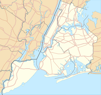
| Borough | Manhattan | ||
| Locale | Financial District, World Trade Center | ||
| Coordinates | 40°42′36″N 74°00′43″W / 40.71°N 74.012°WCoordinates: 40°42′36″N 74°00′43″W / 40.71°N 74.012°W | ||
| Division | A (IRT) | ||
| Line | IRT Broadway–Seventh Avenue Line | ||
| Services | no regular service | ||
| Transit connections |
| ||
| Structure | Underground | ||
| Platforms | 2 side platforms | ||
| Tracks | 2 | ||
| Other information | |||
| Opened | July 1, 1918 | ||
| Closed | September 11, 2001 | ||
| Rebuilt | 2018 (projected)[1] | ||
| Former/other names | Cortlandt Street–World Trade Center | ||
| Traffic | |||
| Passengers (2015) |
0[2] | ||
| Rank | 422 out of 422 | ||
| Station succession | |||
| Next north | Chambers Street: no regular service | ||
| Next south | Rector Street: no regular service | ||
| |||


Cortlandt Street (also known as Cortlandt Street–World Trade Center) is a temporarily closed station on the IRT Broadway–Seventh Avenue Line of the New York City Subway in Lower Manhattan. The station was demolished after sustaining heavy damage during the September 11 attacks and is currently being reconstructed as a part of the World Trade Center Transportation Hub.
Station layout
| G | Street Level | Entrances/Exits |
| M | Mezzanine | Fare control, station agent |
| P Platform level |
Side platform, under construction | |
| Northbound | ← ← | |
| Southbound | → → | |
| Side platform, under construction | ||
The original station was originally located under Cortlandt and Greenwich streets, with a standard two side platform layout with two tracks, the rebuilt station will be built directly under the National September 11 Memorial & Museum, under Greenwich street. It will be connected to the Cortlandt Street (BMT), Chambers Street–World Trade Center/Park Place, and World Trade Center (PATH) stations to become the World Trade Center Transportation Hub.
History
Early history
The station was named after Cortlandt Street, which formerly ran east and west from Broadway to West Street in Lower Manhattan, nicknamed "Radio Row" because of the many electronics dealers on the street. The station was constructed and opened in 1918. It was originally located under Cortlandt and Greenwich streets, with a standard two side platform layout with two tracks and mosaic decorations by Squire J. Vickers depicting a ship.
In 1965, Cortlandt Street west of Church Street was demolished to create the superblock of the World Trade Center. The station, with entrances at Vesey Street and inside the World Trade Center concourse, was not particularly close to the remaining block of Cortlandt Street. The old tiling and mosaics disappeared and were replaced with 1970s-style tiles, which essentially was varnished, tan-colored bricks. One of the Vickers mosaics is preserved in the New York Transit Museum.
September 11 attacks
The station and the surrounding subway tunnels were severely damaged in the September 11, 2001 terrorist attacks from the collapse of Two World Trade Center, resulting in the closure of the line south of Chambers Street. The steel I-beams of the station were crumpled and the station roof began to collapse. To quickly restore service to Rector Street and South Ferry stations to the south, workers demolished the remainder of the station and built walls where the platforms used to be. About 1,000 feet (300 m) of tunnels and trackage, including 575 feet (175 m) of totally destroyed tunnels and tracks in the vicinity of the station site as it traversed Ground Zero, were entirely rebuilt. However, officials wanted only to reopen Rector and South Ferry stations at the time, and Cortlandt Street was to be closed completely, with no replacement station. Eventually, it was decided that the Cortlandt Street station was to be demolished and rebuilt as part of the greater World Trade Center reconstruction project, since Cortlandt Street was such a vital station in the area and since a permanent closure would have been unfeasible.[3] The line reopened on September 15, 2002, with trains bypassing the site of the Cortlandt Street station.[4]
The northern entrance at Vesey Street was under a staircase to the plaza above. After the World Trade Center collapse on September 11, the staircase still stood and became known as the Survivors' Staircase.[5] The stairs were moved into the National September 11 Museum in July 2008.[6]
Reconstruction and delays
In October 2008, the Port Authority of New York and New Jersey (PANYNJ) stated in a report that it had come to an agreement with the MTA on reconstructing the Cortlandt Street station. The MTA would pay the Port Authority to rebuild the station as part of the Port Authority's World Trade Center Transportation Hub contract, in order to make the construction process more efficient. The Port Authority was set to complete underpinning and excavation under the tunnel structure by the second quarter of 2010, and start basic construction of the station during the 3rd quarter. Station finishes would start during the second quarter of 2011.[7] In the 2010–2nd Quarter report, the Port Authority of New York and New Jersey confirmed that excavation under the tunnel structure of the World Trade Center site was nearly complete, and that construction of the Cortlandt Street station would begin during the 3rd quarter of 2010.[8] As of September 2011, work continues on the station mezzanine and platforms.[1]
Disputes between the PANYNJ and the MTA over who would pay for the renovation had caused the planned opening of the station to be delayed from 2014 to 2018. In 2013, the PANYNJ awarded a contract to rebuild the station. The first phase of the demolition of the original station cost $19 million.[9] As of December 2013, the area is still being rebuilt,[10] and as of February 2015, the PANYNJ and the MTA have agreed to finish the station. The part of the Broadway–Seventh Avenue Line on which Cortlandt Street station is located, south of Chambers Street, will probably be partially or intermittently closed between 2015 and 2018 to allow the station to resume construction.[11]
The tracks are walled off for the protection of the workers while the construction is underway. As a result of the massive excavation in the World Trade Center site, the 1 train uses an enclosed elevated structure briefly when passing the site of the station. The station is planned to have a connection to the World Trade Center Transportation Hub and the Fulton Center when it reopens.[1][9] Station finishes, including tiles and lighting, will be installed in the station between May 2015 and 2018.[12] The PANYNJ is set to give "full access" to the station to the MTA in June 2017 once the temporary World Trade Center PATH entrance is demolished and the Cortlandt Street station foundation is poured.[13] The reconstruction of the station is set to cost $101 million[12] and will include new Americans with Disabilities Act-compliant entrances with elevators.[13] A $1 million weaving-based artwork by Ann Hamilton will be installed in the station by MTA Arts and Design; this artwork would feature words, from an undetermined historical document, engraved into the station walls.[12]
Image gallery
 The ruins of the former Vesey Street entrance in 2006
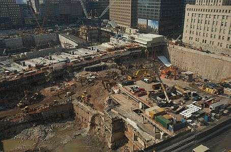 The WTC site in 2008. The concrete structure at top is a subway tunnel that includes the former location of the Cortlandt Street station
References
- 1 2 3 Jennifer Fermino (September 7, 2011). "Cortlandt Street station comes back to life". New York Post. New York City: New York Post. Retrieved April 17, 2014.
- ↑ "Facts and Figures: Annual Subway Ridership". Metropolitan Transportation Authority. Retrieved 2016-04-19.
- ↑ Kennedy, Randy (January 4, 2002). "Subway Line In Attack May Reopen Much Earlier". The New York Times. New York City: The New York Times. Retrieved April 17, 2014.
- ↑ Kennedy, Randy (September 17, 2002). "Tunnel Vision; With Station's Reopening, Even Commuters Smile". The New York Times. New York City: The New York Times. Retrieved October 6, 2007.
- ↑ Pinto, Nick (October 1, 2007). "Last Days Of The Lost Station". The Tribeca Trib.
- ↑ Dunlap, David (July 18, 2008). "A Last Glimpse of the Survivors' Stairway". City Room. New York Times. Retrieved April 22, 2012.
- ↑ World Trade Center Report: A Roadmap Forward - Port Authority of New York and New Jersey, October 2008, page 50
- ↑ World Trade Center Quarterly Report - 2nd Quarter 2010, pp. 9, 11
- 1 2 "NYC Subway Station Destroyed on 9/11 to Reopen in 2018". WNBC. New York City: NBC New York. February 23, 2015. Retrieved February 24, 2015.
- ↑ Work at Cortlandt Street station #1 train continues above ground at WTC Transportation Hub
- ↑ Jose Martinez (23 February 2015). "Cortlandt Street Station, Destroyed in 9/11, to Get New Life". NY1. Retrieved 11 March 2015.
- 1 2 3 Dunlap, David (28 April 2015). "At Cortlandt Street Subway Station, Art Woven From Words". The New York Times. Retrieved 30 April 2015.
- 1 2 "Capital Program Oversight Committee Meeting - March 2016" (PDF). mta.info. Metropolitan Transportation Authority. March 21, 2016. Retrieved July 5, 2016.
Further reading
- Lee Stokey. Subway Ceramics : A History and Iconography. 1994. ISBN 978-0-9635486-1-0
- The New York Times. Photogallery: construction at the site of the World Trade Center. Image 16: A network of columns and beams, visible in the center left, holds the No. 1 subway tunnel 50 feet above ground
- The New York Times. Ground Zero’s Train in a Box, Above a Forest of Steel. May 8, 2008
External links
|
| |
|
| |
|
| |
|
| |
|
|
- Joseph Brennan (2002). "Abandoned Stations: Cortlandt Street". Retrieved 2014-04-17.
- nycsubway.org – IRT West Side Line: Cortlandt Street-World Trade Center