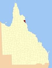
County of Solander
| Solander Queensland | |||||||||||||
|---|---|---|---|---|---|---|---|---|---|---|---|---|---|
 Location within Queensland | |||||||||||||
| |||||||||||||
The county of Solander is a cadastral division of Queensland which contains the towns of Ayton, Daintree, Mossman and Port Douglas. It was originally the southern part of the county of Banks when the counties were named and bounded in 1901.[1][2]
Parishes
Solander is subdivided into parishes, listed as follows:
| Parish | LGA | Coordinates | Towns |
|---|---|---|---|
| Alexandra | Douglas | 16°12′S 145°29′E / 16.200°S 145.483°E | Alexandra Bay |
| Amy | Douglas | 16°4′S 144°57′E / 16.067°S 144.950°E | |
| Bloomfield | Douglas | 16°4′S 145°9′E / 16.067°S 145.150°E | |
| Clerk | Cook | 15°54′S 145°17′E / 15.900°S 145.283°E | Ayton |
| Dagmar | Douglas | 16°13′S 145°12′E / 16.217°S 145.200°E | |
| Dedin | Douglas | 16°22′S 145°16′E / 16.367°S 145.267°E | |
| Kingsdale | Cook | 15°47′S 144°57′E / 15.783°S 144.950°E | |
| Mowbray | Douglas | 16°36′S 145°27′E / 16.600°S 145.450°E | |
| Noah | Douglas | 16°6′S 145°21′E / 16.100°S 145.350°E | Cape Tribulation |
| Phipps | Cook | 15°50′S 145°7′E / 15.833°S 145.117°E | |
| Salisbury | Douglas | 16°32′S 145°26′E / 16.533°S 145.433°E | Port Douglas |
| Sporing | Cook | 15°55′S 145°6′E / 15.917°S 145.100°E | |
| Spurgeon | Douglas | 16°13′S 145°4′E / 16.217°S 145.067°E | |
| Tribulation | Douglas | 16°00′S 145°22′E / 16.000°S 145.367°E | |
| Victory | Douglas | 16°30′S 145°21′E / 16.500°S 145.350°E | Mossman |
| Whyanbeel | Douglas | 16°22′S 145°22′E / 16.367°S 145.367°E | Daintree |
References
- ↑ Queensland government, place name details
- ↑ Cook District, County of Solander Maps - Q4 Series at Queensland Archives.
Coordinates: 16°29′S 145°27′E / 16.483°S 145.450°E
This article is issued from Wikipedia - version of the 4/4/2016. The text is available under the Creative Commons Attribution/Share Alike but additional terms may apply for the media files.