Cours-la-Ville
| Cours-la-Ville | ||
|---|---|---|
|
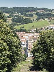
A general view of Cours-la-Ville | ||
| ||
 Cours-la-Ville | ||
|
Location within Auvergne-Rhône-Alpes region  Cours-la-Ville | ||
| Coordinates: 46°06′01″N 4°19′17″E / 46.1003°N 4.3214°ECoordinates: 46°06′01″N 4°19′17″E / 46.1003°N 4.3214°E | ||
| Country | France | |
| Region | Auvergne-Rhône-Alpes | |
| Department | Rhône | |
| Arrondissement | Villefranche-sur-Saône | |
| Canton | Thizy-les-Bourgs | |
| Area1 | 19.48 km2 (7.52 sq mi) | |
| Population (2012)2 | 3,817 | |
| • Density | 200/km2 (510/sq mi) | |
| Time zone | CET (UTC+1) | |
| • Summer (DST) | CEST (UTC+2) | |
| INSEE/Postal code | 69066 / 69470 | |
| Elevation |
437–860 m (1,434–2,822 ft) (avg. 586 m or 1,923 ft) | |
|
1 French Land Register data, which excludes lakes, ponds, glaciers > 1 km² (0.386 sq mi or 247 acres) and river estuaries. 2 Population without double counting: residents of multiple communes (e.g., students and military personnel) only counted once. | ||
.svg.png)
Cours-la-Ville is a former commune in the Rhône department in eastern France. It is the seat of the commune of Cours.
History
It was formed in 1974 by the merger of Cours and La Ville. On 1 January 2016, Cours-la-Ville, Pont-Trambouze and Thel merged becoming one commune called Cours.
International relations
Twin towns – Sister cities
Cours-la-Ville is twinned with:
See also
References
- ↑ "British towns twinned with French towns". Archant Community Media Ltd. Archived from the original on 2013-07-05. Retrieved 2013-07-11.
- ↑ "Winslow Anglo French Twinning Association". Retrieved 23 April 2007.
| Wikimedia Commons has media related to Cours-la-Ville. |
This article is issued from Wikipedia - version of the 12/1/2016. The text is available under the Creative Commons Attribution/Share Alike but additional terms may apply for the media files.