Cowbit
| Cowbit | |
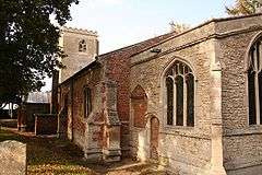 Church of St Mary, Cowbit |
|
 Cowbit |
|
| Population | 1,220 (2011) |
|---|---|
| OS grid reference | TF260178 |
| – London | 85 mi (137 km) S |
| District | South Holland |
| Shire county | Lincolnshire |
| Region | East Midlands |
| Country | England |
| Sovereign state | United Kingdom |
| Post town | Spalding |
| Postcode district | PE12 |
| Police | Lincolnshire |
| Fire | Lincolnshire |
| Ambulance | East Midlands |
| EU Parliament | East Midlands |
| UK Parliament | South Holland and The Deepings |
|
|
Coordinates: 52°44′38″N 0°08′03″W / 52.743769°N 0.134059°W
Cowbit (locally pronounced Cubbit) is a village and civil parish in the South Holland district of Lincolnshire, England.[1] The population of the civil parish at the 2011 census was 1,220.[2] It is situated 3 miles (5 km) south from Spalding and 5 miles (8 km) north from Crowland.
Cowbit falls within the drainage area of the Welland and Deepings Internal Drainage Board.
Cowbit Grade I listed Anglican parish church is dedicated to St Mary.[3] The church was built on a small scale in the 14th century by Prior de Moulton of Spalding. A chancel and Perpendicular tower were added by Bishop Russell of Lincoln in 1487. Restoration was carried out in 1882.[4] A Wesleyan chapel was built in 1842, and rebuilt in 1861.[5] To the south, on the road to the hamlet of Peak Hill, is a stone named after St Guthlac, being a boundary marker for the earlier lands of Crowland Abbey.[5]
The village contains a Grade II listed early 19th-century mill,[6] a Church of England primary school, public play area, village hall, a garage, and a village store.
On 16 October 2011 work was completed on a new bypass for the A1073,[7] which previously ran through the village. This new route has been re-designated to form part of the A16.
Cowbit previously had a railway station on Spalding to March line; the line is no longer in use.
Cowbit Wash lies to the west of the village, extends 8 miles (13 km) from north to south, and is nearly 1 mile (1.6 km) broad.[5] Mainly arable land, it is a flood plain for the navigable River Welland, separated from Cowbit by an earth bank, Barrier Bank, that carries an unclassified road, the former A1073.[8] Previously Welland overflow regularly flooded the Wash, the water freezing-over during winter allowing for ice skating and skating championships. A relief channel (Coronation Channel) for the Welland at Spalding has made Cowbit Wash obsolete as a flood plain since the 1950s.
Since Queen Victoria’s Diamond Jubilee in 1897 there has been a punt gun salute over Cowbit Wash every coronation and jubilee, concurrent with gun salutes in London, including the June 2012 Diamond Jubilee of Elizabeth II.[9][10][11]
References
- ↑ 235 Wisbech & Peterborough North:Market Deeping & Crowland (Map) (A1 ed.). 1:25 000. OS Explorer. OSGB. 3 April 2006. ISBN 978-0-319-23807-3.TF265180
- ↑ "Civil parish population 2011". Neighbourhood Statistics. Office for National Statistics. Retrieved 26 April 2016.
- ↑ Historic England. "Church of St Mary (1064482)". National Heritage List for England. Retrieved 19 July 2011.
- ↑ Cox, J. Charles (1916) Lincolnshire p. 107; Methuen & Co. Ltd
- 1 2 3 Kelly's Directory of Lincolnshire with the port of Hull 1885, p. 369
- ↑ Historic England. "Mill (1359258)". National Heritage List for England. Retrieved 19 July 2011.
- ↑ "A1073 - Spalding to Eye Improvement", Lincolnshire County Council. Retrieved 19 July 2011
- ↑ "Pumping Station, Cowbit Wash, Lincs", Geograph.org.uk. Retrieved 19 July 2011
- ↑ "History of Cowbit... So Far...". Cowbit Village Website. Retrieved 9 August 2013.
- ↑ "Punt gun". HistorianBook.
- ↑ Hodge, Jean (9 June 2012). "Wildfowlers bring out the big guns for celebration". Spalding Guardian.
External links
 Media related to Cowbit at Wikimedia Commons
- "Cowbit", Genuki.org.uk. Retrieved 19 July 2011
- Cowbit School
- Cowbit Village Website
England Portal | |
| Unitary authorities | |
| Boroughs or districts | |
| Major settlements |
|
| Topics | |