Cowesby
| Cowesby | |
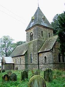
 Cowesby from the south |
|
 Cowesby |
|
| Population | 131 (Including Kirby Knowle. 2001 Census)[1] |
|---|---|
| OS grid reference | SE46540 |
| – London | 231 miles (372 km) |
| Civil parish | Cowesby |
| District | Hambleton |
| Shire county | North Yorkshire |
| Region | Yorkshire and the Humber |
| Country | England |
| Sovereign state | United Kingdom |
| Post town | THIRSK |
| Postcode district | YO7 |
| Police | North Yorkshire |
| Fire | North Yorkshire |
| Ambulance | Yorkshire |
| EU Parliament | Yorkshire and the Humber |
| UK Parliament | Thirsk and Malton |
| Website | http://www.thirsk.org.uk/cowesby/ |
Coordinates: 54°18′07″N 1°17′10″W / 54.302°N 1.286°WCowesby is a village and civil parish in the Hambleton district of North Yorkshire, England. it is on the border of the North York Moors and near the A19, about 4 miles north of Thirsk.
History
The village is mentioned in the Domesday Book as being in the Allerton Hundred and listed as Cahosbi. At the time of the Norman invasion the lands were recorded as belonging to Edwin, Earl of Mercia, but were ceded soon afterwards to King William I, though the manor was in the hands of Hugh, son of Baldric.[2]
Governance
The village lies within the Thirsk and Malton UK Parliament constituency. It also lies within the Thirsk electoral district of North Yorkshire County Council. The village is within the Whitestonecliffe ward of Hambleton District Council.[3]
Geography
According to the 2001 UK Census, the population was 60. There are no local amenities or access to public transport.[4]
The village lies at the foot of the Hambleton Hills in a natural, and thus sheltered, bend just 2 miles (3.2 km) from the A19.[5] The nearest settlements are Kepwick, 0.6 miles (0.97 km) to the north-north-east; Kirby Knowle, 1.6 miles (2.6 km) to the south and Knayton and Borrowby 2.2 miles (3.5 km) to the south-west.[6]
Religion
There is a church in the village dedicated to St. Michael and All Angels.[7] The church was rebuilt in 1846 on the site of the original Saxon building.[5]
References
- ↑ "Civil Parish population 2011". Neighbourhood Statistics. Office for National Statistics. Retrieved 2 August 2015.
- ↑ Cowesby in the Domesday Book. Retrieved 1 December 2012.
- ↑ Ordnance Survey Boundaries
- ↑ "Village facts". Retrieved 1 December 2012.
- 1 2 Bulmer's Topography, History and Directory (Private and Commercial) of North Yorkshire 1890. S&N Publishing. 1890. p. 670. ISBN 1-86150-299-0.
- ↑ Ordnance Survey
- ↑ "Church". Retrieved 1 December 2012.
External links
| Wikimedia Commons has media related to Cowesby. |