Cranleigh Waters
| Cranleigh Waters | |
| Bramley Wey | |
| River | |
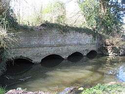 Ruins of Gosden Aqueduct which carried the Wey and Arun Canal over Cranleigh Waters. | |
| Country | England |
|---|---|
| County | Surrey |
| Districts | Guildford, Waverley Mole Valley (unnamed tributaries only) |
| Tributaries | |
| - left | Birtley Brook, Ridings Brook, North Brook, Great Brook, Scotsland Brook, Cold Bourne, Nore Brook/Smithbrook |
| - right | Thornhurst Brook, Coneyhurst Gill, Cobbler's Brook |
| Source | |
| - location | Walliswood, Surrey, England |
| - elevation | 45 m (148 ft) |
| - coordinates | 51°8′14″N 0°24′51″W / 51.13722°N 0.41417°W |
| Mouth | River Wey |
| - location | Shalford |
| Discharge | for Bramley [1] |
| - average | 1.10 m3/s (39 cu ft/s) |
| - min | 0.16 m3/s (6 cu ft/s) (19 June 1998) |
The Cranleigh Waters or Bramley Wey is a tributary of the River Wey in Surrey.
Course
The Cranleigh Waters or Bramley Wey rises at a source close to the sources of two tributaries, the Thornhurst Brook and Coneyhurst Gill in the rural north of Cranleigh, each flowing initially southwestwards to Vachery Pond, before turning to run northwards as the border of Wonersh and Bramley to meet the Wey at Shalford.[2][3]
From the Vachery Pond to the Wey, Cranleigh Waters is closely paralleled by the disused Wey and Arun Canal, which crosses the river at Gosden Aqueduct.[3]
Other tributaries
Cobblers Brook
The Cobblers Brook also rises in the Greensand Ridge as three headwaters in the north of Ewhurst and drains that parish entirely southwards, before flowing west via the Baynards Park estate in Cranleigh into the Vachery Pond.[3]
Unnamed streams in Walliswood
A central natural drainage divide cuts off the rural west and south of the Walliswood hamlet of Abinger, Surrey from the rest of it. This part has three unnamed streams which drain a small fraction of the long north-south oriented parish (lying east of Ewhurst) and flow into the Cobblers Brook in the far south of Ewhurst.[3]
Named left tributaries
These eight left tributaries (when looking downstream in the conventional way) are considerably shorter than the three principal right tributaries and drain a portion of Dunsfold and almost all of Bramley (parishes). They are separated from the River Wey (south branch) by a western high and wide outcrop of the Greensand Ridge.
References
- ↑ Marsh, T; Hannaford, J, eds. (2008). UK Hydrometric Register (PDF). Hydrological data UK series. Wallingford, Oxfordshire: Centre for Ecology & Hydrology. ISBN 978-0-9557672-2-7.
- ↑ Gallois RW; Worssam BC; Thurrell RG (1993). Geology of the County around Horsham. London: HMSO. pp. 95–101. ISBN 978-0-11-884480-2.
- 1 2 3 4 OS Map of English Heritage Listed Buildings and Parks and Gardens Database Archived April 24, 2012, at the Wayback Machine.