Cresswell railway station
| Cresswell | |
|---|---|
|
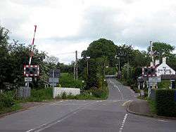
Level crossing at the site of the former station | |
| Location | |
| Place | Cresswell, Staffordshire |
| Area | Staffordshire Moorlands |
| Grid reference | SJ975394 |
| Operations | |
| Pre-grouping | North Staffordshire Railway |
| Post-grouping |
London, Midland and Scottish Railway London Midland Region of British Railways |
| Platforms | 2 |
| History | |
| 7 August 1848 | Opened[1] |
| 7 November 1966 | Closed[1] |
| Disused railway stations in the United Kingdom | |
|
Closed railway stations in Britain A B C D–F G H–J K–L M–O P–R S T–V W–Z | |
|
| |
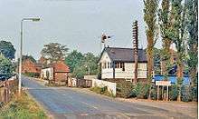
Cresswell railway station was a railway station located on the Stoke-Derby line at Cresswell, Staffordshire, England. It was opened by the North Staffordshire Railway in 1848 and closed in 1966.[2]
The station was located near the Izaak Walton pub and had a substantial building and a small goods yard. It became the junction station for the Cheadle Branch Line in 1892.[2] When the latter closed to passengers, the sidings remained in occasional use for another 20 years, mainly sand traffic from Cheadle.[3]
The level crossing was converted to automatic barrier operation in 1989, whereupon the signal box was demolished and the junction was lifted.[4]
There is no trace of the station today.[3]
| Preceding station | Historical railways | Following station | ||
|---|---|---|---|---|
Line and station open | North Staffordshire Railway | Line open, station closed |
||
| Terminus | North Staffordshire Railway | Line and station closed |
References
- 1 2 Quick, Michael (2009) [2001]. Railway passenger stations in Great Britain: a chronology (4th ed.). Oxford: Railway and Canal Historical Society. p. 137. ISBN 978-0-901461-57-5. OCLC 612226077.
- 1 2 Baker, Allan C. (1979). The Cheadle Railway. The Oakwood Press. ISBN 0-85361-248-X.
- 1 2 Ballantyne, Hugh (2005). British Railways Past & Present: North Staffordshire and the Trent Valley. Past & Present Publishing Ltd. ISBN 1-85895-204-2.
- ↑ "Railways in Draycott". Archived from the original on 2006-05-11. Retrieved 2009-01-21.
Coordinates: 52°57′03″N 2°02′13″W / 52.95089°N 2.03705°W