Cugnot Ice Piedmont
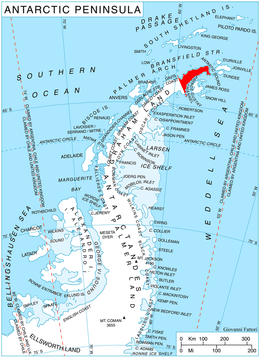
Cugnot Ice Piedmont (63°38′S 58°10′W / 63.633°S 58.167°WCoordinates: 63°38′S 58°10′W / 63.633°S 58.167°W) is an ice piedmont in Trinity Peninsula, about 15 nautical miles (30 km) long and between 3 and 6 nautical miles (6 and 11 km) wide, extending from Russell East Glacier to Eyrie Bay and bounded on the landward side by Louis Philippe Plateau. It was mapped from surveys by the Falkland Islands Dependencies Survey (1960–61), and named by the UK Antarctic Place-Names Committee for Nicolas J. Cugnot, a French military engineer who designed and built the first full-sized vehicle propelled by its own engine (steam), in 1769.[1]
Map
- Trinity Peninsula. Scale 1:250000 topographic map No. 5697. Institut für Angewandte Geodäsie and British Antarctic Survey, 1996.
References
- ↑ "Cugnot Ice Piedmont". Geographic Names Information System. United States Geological Survey. Retrieved 2011-12-08.
![]() This article incorporates public domain material from the United States Geological Survey document "Cugnot Ice Piedmont" (content from the Geographic Names Information System).
This article incorporates public domain material from the United States Geological Survey document "Cugnot Ice Piedmont" (content from the Geographic Names Information System).