Culberson County Airport
| Culberson County Airport | |||||||||||||||
|---|---|---|---|---|---|---|---|---|---|---|---|---|---|---|---|
|
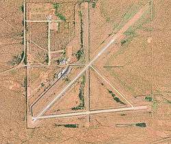
2006 USGS Airphoto | |||||||||||||||
| IATA: VHN – ICAO: KVHN – FAA LID: VHN | |||||||||||||||
| Summary | |||||||||||||||
| Airport type | Public | ||||||||||||||
| Owner | Culberson County | ||||||||||||||
| Location | Culberson County, near Van Horn, Texas | ||||||||||||||
| Elevation AMSL | 3,957 ft / 1,206 m | ||||||||||||||
| Coordinates | 31°03′28″N 104°47′02″W / 31.05778°N 104.78389°WCoordinates: 31°03′28″N 104°47′02″W / 31.05778°N 104.78389°W | ||||||||||||||
| Map | |||||||||||||||
 KVHN Location of Culberson County Airport | |||||||||||||||
| Runways | |||||||||||||||
| |||||||||||||||
| Statistics (2007) | |||||||||||||||
| |||||||||||||||
Culberson County Airport (IATA: VHN, ICAO: KVHN, FAA LID: VHN) is a county-owned public-use airport located three miles (5 km) northeast of the central business district of Van Horn, a town in Culberson County, Texas, United States.[1]
Facilities and aircraft
Culberson County Airport covers an area of 1,000 acres (405 ha) which contains two asphalt paved runways: 3/21 measuring 6,000 x 75 ft. (1,829 x 23 m) and 7/25 measuring 5,353 x 75 ft. (1,632 x 23 m). For the 12-month period ending April 27, 2007, the airport had 500 aircraft operations: 60% general aviation and 40% military.[1]
History
During World War II the airfield was used by the United States Army Air Forces
See also
References
External links
- Resources for this airport:
- FAA airport information for VHN
- AirNav airport information for VHN
- ASN accident history for VHN
- FlightAware airport information and live flight tracker
- SkyVector aeronautical chart for VHN
This article is issued from Wikipedia - version of the 12/4/2016. The text is available under the Creative Commons Attribution/Share Alike but additional terms may apply for the media files.