Cumberland Sound
| Cumberland Sound | |
|---|---|
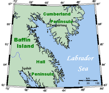
 Cumberland Sound, a part of the Labrador Sea, between Cumberland Peninsula and Hall Peninsula. | |
| Location | Labrador Sea |
| Coordinates | 65°13′N 065°45′W / 65.217°N 65.750°WCoordinates: 65°13′N 065°45′W / 65.217°N 65.750°W |
| Basin countries | Canada |
| Settlements | Pangnirtung |
Cumberland Sound (Inuit: Kangiqtualuk)[1] (other names: Cumberland Straits; Hogarth Sound; Northumberland Inlet)[2] (Old Norse: ᚠᛁᛋᚦᚱᛁ ᚢᛒᚢᚴᚦᛁᛦ, fisþri ubukþiR), is an Arctic waterway in Qikiqtaaluk Region, Nunavut, Canada. It is a western arm of the Labrador Sea located between Baffin Island's Hall Peninsula and the Cumberland Peninsula. It is approximately 250 km (160 mi) long and 80 km (50 mi) wide.
Small islands litter the stretch of water which was formed from glacial activity and meltwater produced from the receding glacier.
The only settlement located on the shore of the sound on the Cumberland Peninsula is Pangnirtung. John Davis, the English explorer, went part way up the sound in 1585.
Fauna
The bay is home to the Cumberland Sound beluga whale, a species known to reside year-round in the sound, with summers spent at the northern end. As well as ringed, bearded, harp, harbour and hooded seals, there are Arctic char, Greenland halibut, and other fish. Birds such as gulls, ducks, and geese also migrate and spend the spring and summer in Cumberland Sound, and ptarmigan and ravens remain year-round.
References
- ↑ Shelagh Grant. Arctic Justice: On Trial for Murder, Pond Inlet, 1923. McGill-Queen's Press, 2005
- ↑ Kumlien, Ludwig (1879). Contributions to the natural history of Arctic America: made in connection with the Howgate Polar Expedition, 1877-78 (Digitized October 3, 2008 ed.). Govt. Printing Office. p. 11.
- Fisheries and Oceans Canada