Cyclone Keli
| Category 3 severe tropical cyclone (Aus scale) | |
|---|---|
| Category 4 (Saffir–Simpson scale) | |
 Cyclone Keli at peak intensity | |
| Formed | June 7, 1997 |
| Dissipated | June 17, 1997 |
| Highest winds |
10-minute sustained: 150 km/h (90 mph) 1-minute sustained: 215 km/h (130 mph) |
| Lowest pressure | 955 hPa (mbar); 28.2 inHg |
| Fatalities | None reported |
| Damage | $10,000 (1997 USD) |
| Areas affected | Tokelau, Tuvalu, Fiji |
| Part of the 1996–97 South Pacific cyclone season | |
Severe Tropical Cyclone Keli (NPMOC/JTWC Designation: 38P) was the first recorded post-season tropical cyclone to form in June within the South Pacific Ocean.[1][2] The system formed on June 7, 1997, about 460 kilometers (285 mi) to the north of Tokelau. The depression gradually developed over the next few days while moving southwestward. It was designated as Tropical Cyclone Keli early the next day. Cyclone Keli intensified, slowly reaching its 10-minute peak wind speeds of 150 km/h, (90 mph), which made it a Category 3 severe tropical cyclone on the Australian Tropical Cyclone Intensity Scale. As it came under the influence of strong mid latitude westerlies and moved into an area of strong vertical wind shear, the cyclone started to weaken and was declared as extratropical on June 15.
Cyclone Keli struck the islands of Tuvalu on June 12 and 13, with extensive damage reported throughout the Islands with trees uprooted by wind and waves. On Nivalakita, all buildings except for the church were flattened; an estimated cost to rebuild all of the houses as they were before the cyclone hit was estimated at A$12 thousand (US$10 thousand), while it was estimated that the cost of rebuilding the houses with an improved, cyclone-resistant design would be about A$84 thousand (US$63 thousand). The whole of Tepuka Savilivili was left uninhabitable, as coconut trees and other vegetation were swept away with no more than an area of jagged coral left behind. In Fiji, strong winds and rough seas were reported from the cyclone as it was moving to the north of Fiji, and while the cyclone was weakening it dropped 3.76 inches (95.5mm) of rain on American Samoa.
Meteorological history
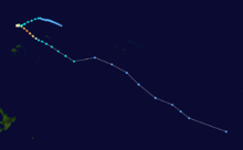
Severe Tropical Cyclone Keli was first noted as a depression, to the northeast of the New Zealand territory of Tokelau during June 7, 1997.[3][4] Over the next couple of days the system moved towards the south-west and gradually developed further, with the United States Naval Pacific Meteorology and Oceanography Center (NPMOC) issuing a tropical cyclone formation alert for the system during June 9.[3][5]
The NPMOC subsequently designated the system as Tropical Cyclone 38P and initiated advisories on the system early on June 10, while the system was located about 475 km (295 mi) to the east of Funafuti, Tuvalu.[6] The system was subsequently named Keli by the Fiji Meteorological Service, after it had developed into a Category 1 tropical cyclone on the Australian tropical cyclone intensity scale.[3][7] During that day the system continued to move south-westwards, towards the island nation of Tuvalu and passed near or over the island of Niulakita during June 11.[8] After it the system had passed over Niulakita, Keli rapidly intensified in an area of light vertical wind shear, as it moved slowly and performed a small cyclonic loop.[4][9]
Early on June 12, the FMS reported that Keli had peaked as a Category 3 severe tropical cyclone, with 10-minute sustained windspeeds of 150 km/h (90 mph).[3][7] During that day the system started to weaken and came to within 65 km (40 mi) of making a second landfall on Niulakita, before it accelerated south-eastwards as it interacted with the Westerlies.[8][9] The NPMOC also reported during that day that Keli had peaked with 1-minute sustained wind speeds of 215 km/h (130 mph), which made it equivalent to a Category 4 hurricane on the Saffir-Simpson hurricane wind scale.[10] During June 13, the system continued to move south-eastwards and passed about 50 km (30 mi) to the southeast of Mata-Utu in the island nation of Wallis and Futuna.[3] Later that day Keli started to transition into an extratropical cyclone, during the following day the system passed within 200 km (125 mi) of Apia, Samoa.[3][11] During June 15, the FMS reported that Keli had weakened into a tropical depression, while the NPMOC reported that it had degenerated into an extratropical cyclone.[7][12] The system was subsequently last noted during June 17, while it was located about 2,140 km (1,330 mi) to the southeast of Adamstown in the Pitcairn Islands.[3]
Impact and aftermath
| Precipitation | Storm | Location | Ref. | ||
|---|---|---|---|---|---|
| Rank | mm | in | |||
| 1 | 674.9 | 26.57 | Raja 1986 | Maopoopo, Futuna Island | [13] |
| 2 | 556.7 | 21.92 | Fran 1992 | Hihifo, Wallis Island | [13] |
| 3 | 291.2 | 11.46 | Val 1975 | Hihifo, Wallis Island | [13] |
| 4 | 220.6 | 8.69 | Hina 1997 | Maopoopo, Futuna Island | [13] |
| 5 | 186.0 | 7.32 | Evan 2012 | Futuna Island | [14] |
| 6 | 180.0 | 7.09 | Val 1980 | Maopoopo, Futuna Island | [13] |
| 7 | 171.6 | 6.76 | Keli 1997 | Hihifo, Wallis Island | [13] |
| 8 | 160.8 | 6.33 | Unnamed 1966 | Malaetoli, Wallis Island | [13] |
| 9 | 160.0 | 6.30 | Amos 2016 | Hihifo, Wallis Island | [15] |
| 10 | 119.0 | 4.69 | Waka 2001 | Hihifo, Wallis Island | [13] |
Heavy rain was reported in American Samoa with a rainfall total, of 160 mm (6.3 in) reported at Afono in American Samoa.[16] The name Keli was retired after this usage of the name and was replaced with the name Kofi.[17][18]
Tuvalu

Keli was the third and final tropical cyclone to impact Tuvalu during the 1996-97 season, after Severe Tropical Cyclone's Gavin and Hina affected the island nation during March 1997.[19] Ahead of the system impacting Tuvalu, storm and gale force wind warnings were issued for the islands of Niulakita and Nukulaelae, while a strong wind warning was issued for the rest of the group during June 10.[8] During that day the system moved south-westwards and passed near or over Niulakita later that day, before it performed a cyclonic loop and passed within 65 km (40 mi) of Niulakita during June 12.[8]
As Cyclone Keli struck the islands of Tuvalu on June 12 and 13, peak wind gusts of 165 km/h, (105 mph) were reported, with extensive damage also reported throughout the Islands with trees uprooted by wind and waves.[20] On Nivalakita all buildings except for the church were flattened with an estimated cost to rebuild the houses exactly as they were was estimated at A$12,000 (US$10,000 1997), while it was estimated that the cost of rebuilding the houses with an improved, cyclone-resistant design would be about A$84,000 (63,000 USD 1997).[21] Also on Nivalakita communications were cut with the telephone operator having to resort to sending a Morse code message, however as the storm re-curved and re-hit Tuvalu on June 14, it silenced the weak radio telegraph system.[20] In Tepuka Savilivili the whole island was left uninhabitable as coconut trees and other vegetation were swept away with no more than an area of jagged coral left behind.[22][23]
With effect from June 12, a state of public emergency was declared for the whole of Tuvalu, by the then Governor-General of Tuvalu, Sir Tulaga Manuella.[8] This was because there was only a limited amount of food available on Funafuti to cater for the whole of the island nation, while providing Niulakita with immediate relief supplies.[8] This enabled the Tuvaluan embassy in Suva, Fiji to appeal to various overseas countries and organisations including Australia, New Zealand, the United Kingdom and the United Nations Development Programme to provide aid and assistance to the island nation.[8][24][25] During June 14, the Royal New Zealand Air Force deployed a transport plane carrying some relief materials including tarpaulins and water from New Zealand. The plane subsequently stopped in Noumea, New Caledonia and Nadi, Fiji to pick up further relief supplies that had been donated by Australia, Fiji and France.[8][26] The crew of the plane subsequently conducted an aerial assessment of the damage on Niulakita, and reported seeing widespread damage, before they arrived at Funafuti Airport during June 15.[8][27]
Wallis and Futuna
Cyclone Keli was the third out of four tropical cyclones to impact the French Territory of Wallis and Futuna during a ten-month period, after Cyclones Gavin and Hina had affected the island during March 1997.[28][29][30] There was almost no damage recorded in the archipeligo from Keli, while rainfall totals of 171.6 mm (6.76 in) and 160 mm (6.3 in) were recorded at Hihifo and Aka'aka on Wallis during June 11.[29] Wind gusts of up to 70 km/h (45 mph) were recorded at Maopoopo on Futuna island during July 13.[29]
Tonga
Keli was the second of three tropical cyclones to affect Tonga during a ten-month period, with Cyclones Hina and Ron affecting the island nation during March 1997 and January 1998.[31] Ahead of the system impacting Tonga, the FMS issued cyclone warnings for the Niuas and strong wind warnings for the rest of Tonga.[32] As a result of the warnings a vessel that was heading to the island group had to be recalled, which was predicted to affect supplies on the islands when it was likely to be most needed.[32] During June 13, Keli caused some damage to the islands with plantations, breadfruit trees and other large trees devastated.[32] The strong winds also destroyed several residences while causing damage to public buildings.[32]
See also
References
- ↑ "Tropical Cyclone Information for the Southern Hemisphere". Bureau of Meteorology. 2009. Retrieved 2009-08-31.
- ↑ "Asia-Pacific Workshop on Indicators and Indices for Monitoring Trends in Climate Extremes". Bureau of Meteorology. 1998-12-10. p. 43. Retrieved 2009-08-26.
- 1 2 3 4 5 6 7 MetService (May 22, 2009). "TCWC Wellington Best Track Data 1967–2006". International Best Track Archive for Climate Stewardship.
- 1 2 Darwin Regional Specialised Meteorological Centre (1997). "June 1997" (PDF). Darwin Tropical Diagnostic Statement. Australian Bureau of Meteorology. 16 (6): 2. ISSN 1321-4233. Archived (PDF) from the original on May 20, 2012. Retrieved October 10, 2015.
- ↑ Tropical Cyclone Formation Alert June 9, 1997 11z (Report). Naval Pacific Meteorology and Oceanography Center. June 9, 1997. Archived from the original on August 8, 2013. Retrieved April 2, 2014.
- ↑ Naval Pacific Meteorology and Oceanography Center (June 10, 1997). Tropical Cyclone 38P (Keli) Warning 1; June 10, 1997 03z (Report). United States Navy, United States Air Force. Archived from the original on August 8, 2013. Retrieved April 2, 2014.
- 1 2 3 Hanstrum, Barry N; Reader, Grahame; Bate, Peter W (September 3, 1999). "The South Pacific and Southeast Indian Ocean Tropical Cyclone Season 1996–97" (PDF). Australian Meteorological Magazine. 48 (3): 209–210. Archived (PDF) from the original on August 4, 2013. Retrieved August 8, 2013.
- 1 2 3 4 5 6 7 8 9 Damage Assessment Team (1997). Tropical Cyclone Keli: June 10 - 13, 1997, Report on the extent of damage (PDF) (Report). Tuvalu Government. Archived (PDF) from the original on October 10, 2015. Retrieved October 10, 2015.
- 1 2 Tropical Cyclone 38P (Keli) Warning 6; June 12, 1997 15z (Report). Joint Typhoon Warning Center. June 12, 1997. Archived from the original on August 8, 2013. Retrieved October 10, 2015.
- ↑ Joint Typhoon Warning Center; Naval Pacific Meteorology and Oceanography Center. "Tropical Cyclone 38P (Keli) Best Track Analysis". United States Navy, United States Airforce. Archived from the original on 2012-05-22. Retrieved October 10, 2015.
- ↑ Naval Pacific Meteorology and Oceanography Center (June 13, 1997). Tropical Cyclone 38P (Keli) Warning 8; June 13, 1997 15z (Report). Archived from the original on August 8, 2013. Retrieved October 10, 2015.
- ↑ Naval Pacific Meteorology and Oceanography Center (June 15, 1997). Tropical Cyclone 38P (Keli) Warning 11; June 15, 1997 03z (Report). United States Navy, United States Air Force. Archived from the original on August 8, 2013. Retrieved August 8, 2013.
- 1 2 3 4 5 6 7 8 "Wallis and Futuna Cyclone Passes De 1880 à nos jours" (in French). Meteo France New Caledonia. Retrieved January 2, 2014.
- ↑ "156 km/h : Record de rafales battu à Wallis" (in French). Meteo France: New Caledonia. December 22, 2012. Archived from the original on December 22, 2012. Retrieved November 26, 2016.
- ↑ "Cyclone Amos: les Samoa ravagées". Meteo (in French). Retrieved April 24, 2016.
- ↑ Roth, David M. (April 29, 2015). "Tropical Cyclone Point Maxima". Tropical Cyclone Rainfall Data. United States Weather Prediction Center. Retrieved May 8, 2016.
- ↑ RA V Tropical Cyclone Committee (December 12, 2012). List of Tropical Cyclone Names withdrawn from use due to a Cyclone's Negative Impact on one or more countries (PDF) (Tropical Cyclone Operational Plan for the South-East Indian Ocean and the Southern Pacific Ocean 2012). World Meteorological Organization. pp. 2B–1 – 2B–4 (23 – 26). Archived (PDF) from the original on April 1, 2013. Retrieved December 14, 2012.
- ↑ "Tropical cyclone names: Fiji". United Kingdom Met Office. July 18, 2013. Archived from the original on August 7, 2013. Retrieved August 7, 2013.
- ↑ Prasad, Vikash R; RSMC Nadi — Tropical Cyclone Centre (March 4, 1998). Tropical Cyclone Hina: March 13 - 16, 1997 (PDF) (Tropical Cyclone Report: 96/8). Fiji Meteorological Service. Archived (PDF) from the original on August 4, 2013. Retrieved July 29, 2013.
- 1 2 Steve Newman (June 24, 1997). "EARTHWEEK: A diary of the planet". The Gainesville Sun. Retrieved August 30, 2009.
- ↑ Emily M (March 17, 2006). "Tool One: Guidelines for estimating the economic impact of natural disasters" (PDF). Aus Aid. Retrieved August 30, 2009.
- ↑ Bikenibeu Paeniu (December 7, 1997). "Tuvalu and Global Warming". Tuvalu Islands. Retrieved August 30, 2009.
- ↑ Angie Knox (August 28, 2002). "Sinking feeling in Tuvalu". BBC News. Retrieved August 30, 2009.
- ↑ "Neighbours fly aid to cyclone-hit island in South Pacific [AM Cycle]". The Associated Press. June 14, 1997. – via Lexis Nexis (subscription required)
- ↑ "Neighbours fly aid to cyclone-hit island in South Pacific [PM Cycle]". The Associated Press. June 14, 1997. – via Lexis Nexis (subscription required)
- ↑ "Damage still undetermined on cyclone-hit Tuvalu". The Associated Press. June 15, 1997. Archived from the original on October 10, 2015. Retrieved October 10, 2015.
- ↑ "New Zealand crew reports widespread damage on Tuvalu atoll". Wellington, New Zealand. The Associated Press. June 16, 1997.
- ↑ Kersemakers, Mark; RSMC Nadi — Tropical Cyclone Centre (April 4, 1998). Tropical Cyclone Gavin: March 2 — 11, 1997 (PDF) (Tropical Cyclone Report 96/7). Fiji Meteorological Service. pp. 1–11, 21. Retrieved January 31, 2013.
- 1 2 3 "Wallis and Futuna Cyclone Passes De 1880 à nos jours". Meteo France. Retrieved May 14, 2012.
- ↑ "Cyclone Keli might force a cancellation of Saturday's". Agence France Presse. June 14, 1997. – via Lexis Nexis (subscription required)
- ↑ A report on the list of the tropical cyclones that has affected at least a part of Tonga from 1960 to Present (PDF) (Report). Tonga Meteorological Service. Retrieved January 2, 2014.
- 1 2 3 4 "In the Eye of the Storm, A nation in waiting". Island Snapshot. June 12, 1997. Archived from the original on October 10, 2015. Retrieved October 11, 2015.
External links
- World Meteorological Organization
- Australian Bureau of Meteorology
- Fiji Meteorological Service
- Meteorological Service of New Zealand
- Joint Typhoon Warning Center
| 1970s | |
|---|---|
| 1980s | |
| 1990s | |
| 2000s | |
| 2010s | |
| |
Tropical cyclones of the 1996–97 South Pacific cyclone season | ||
|---|---|---|
 | ||
| ||